You are here: Home > Network List > CN - Canadian National Seismograph Network Stations List
> Station INK INUVIK, NT > Earthquake Result Viewer
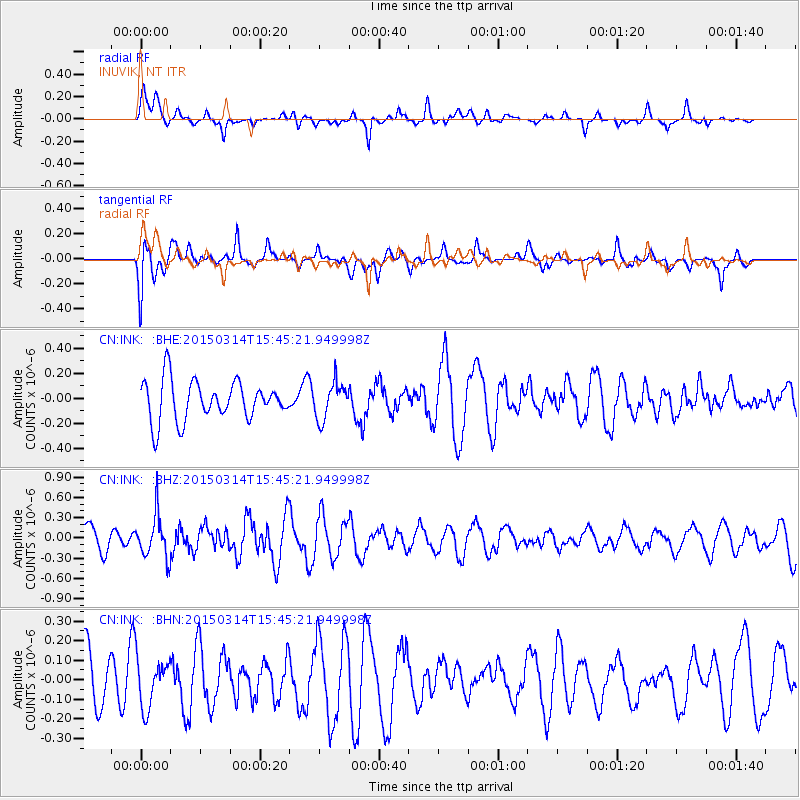
INK INUVIK, NT - Earthquake Result Viewer
*The percent match for this event was below the threshold and hence no stack was calculated.
| Earthquake location: |
Off East Coast Of Honshu, Japan |
| Earthquake latitude/longitude: |
34.3/141.6 |
| Earthquake time(UTC): |
2015/03/14 (073) 15:36:10 GMT |
| Earthquake Depth: |
17 km |
| Earthquake Magnitude: |
5.0 MW |
| Earthquake Catalog/Contributor: |
ISC/ISC |
|
| Network: |
CN Canadian National Seismograph Network |
| Station: |
INK INUVIK, NT |
| Lat/Lon: |
68.31 N/133.53 W |
| Elevation: |
44 m |
|
| Distance: |
56.7 deg |
| Az: |
26.284 deg |
| Baz: |
279.636 deg |
| Ray Param: |
$rayparam |
*The percent match for this event was below the threshold and hence was not used in the summary stack. |
|
| Radial Match: |
46.686474 % |
| Radial Bump: |
365 |
| Transverse Match: |
68.54931 % |
| Transverse Bump: |
400 |
| SOD ConfigId: |
7019011 |
| Insert Time: |
2019-04-17 08:15:12.792 +0000 |
| GWidth: |
2.5 |
| Max Bumps: |
400 |
| Tol: |
0.001 |
|
Signal To Noise
| Channel | StoN | STA | LTA |
| CN:INK: :BHZ:20150314T15:45:21.949998Z | 1.7235183 | 3.1478348E-7 | 1.8264006E-7 |
| CN:INK: :BHN:20150314T15:45:21.949998Z | 0.6635661 | 1.2373644E-7 | 1.8647191E-7 |
| CN:INK: :BHE:20150314T15:45:21.949998Z | 0.91655266 | 1.4420847E-7 | 1.573379E-7 |
| Arrivals |
| Ps | |
| PpPs | |
| PsPs/PpSs | |


