You are here: Home > Network List > TA - USArray Transportable Network (new EarthScope stations) Stations List
> Station M53A WI Miller and Sons, Farmdale, OH, USA > Earthquake Result Viewer
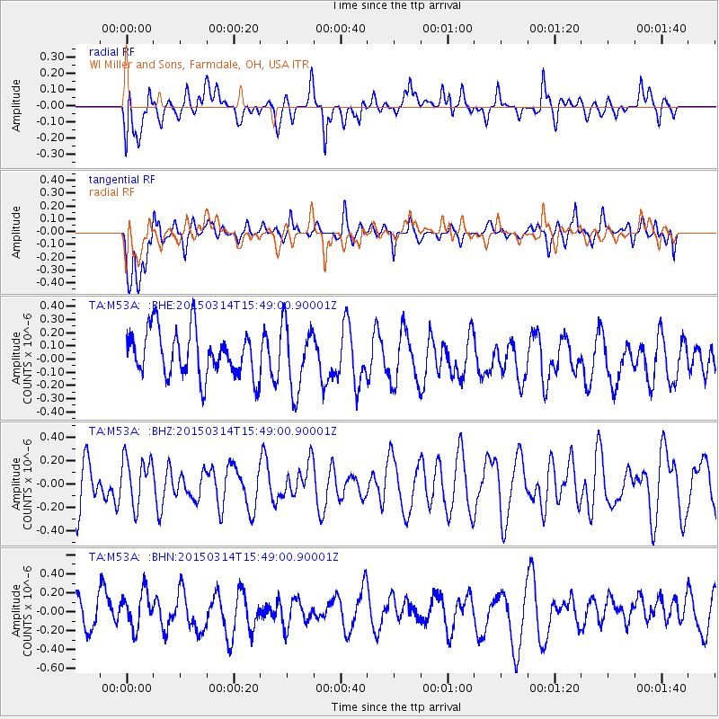
M53A WI Miller and Sons, Farmdale, OH, USA - Earthquake Result Viewer
*The percent match for this event was below the threshold and hence no stack was calculated.
| Earthquake location: |
Off East Coast Of Honshu, Japan |
| Earthquake latitude/longitude: |
34.3/141.6 |
| Earthquake time(UTC): |
2015/03/14 (073) 15:36:10 GMT |
| Earthquake Depth: |
17 km |
| Earthquake Magnitude: |
5.0 MW |
| Earthquake Catalog/Contributor: |
ISC/ISC |
|
| Network: |
TA USArray Transportable Network (new EarthScope stations) |
| Station: |
M53A WI Miller and Sons, Farmdale, OH, USA |
| Lat/Lon: |
41.44 N/80.68 W |
| Elevation: |
334 m |
|
| Distance: |
95.2 deg |
| Az: |
30.52 deg |
| Baz: |
326.006 deg |
| Ray Param: |
$rayparam |
*The percent match for this event was below the threshold and hence was not used in the summary stack. |
|
| Radial Match: |
42.49421 % |
| Radial Bump: |
400 |
| Transverse Match: |
51.7529 % |
| Transverse Bump: |
400 |
| SOD ConfigId: |
7019011 |
| Insert Time: |
2019-04-17 08:19:54.950 +0000 |
| GWidth: |
2.5 |
| Max Bumps: |
400 |
| Tol: |
0.001 |
|
Signal To Noise
| Channel | StoN | STA | LTA |
| TA:M53A: :BHZ:20150314T15:49:00.90001Z | 1.1503164 | 2.0608152E-7 | 1.7915204E-7 |
| TA:M53A: :BHN:20150314T15:49:00.90001Z | 0.95016897 | 2.0953331E-7 | 2.2052215E-7 |
| TA:M53A: :BHE:20150314T15:49:00.90001Z | 1.4421705 | 2.5331985E-7 | 1.756518E-7 |
| Arrivals |
| Ps | |
| PpPs | |
| PsPs/PpSs | |


