You are here: Home > Network List > TA - USArray Transportable Network (new EarthScope stations) Stations List
> Station O60A Telford, PA, USA > Earthquake Result Viewer
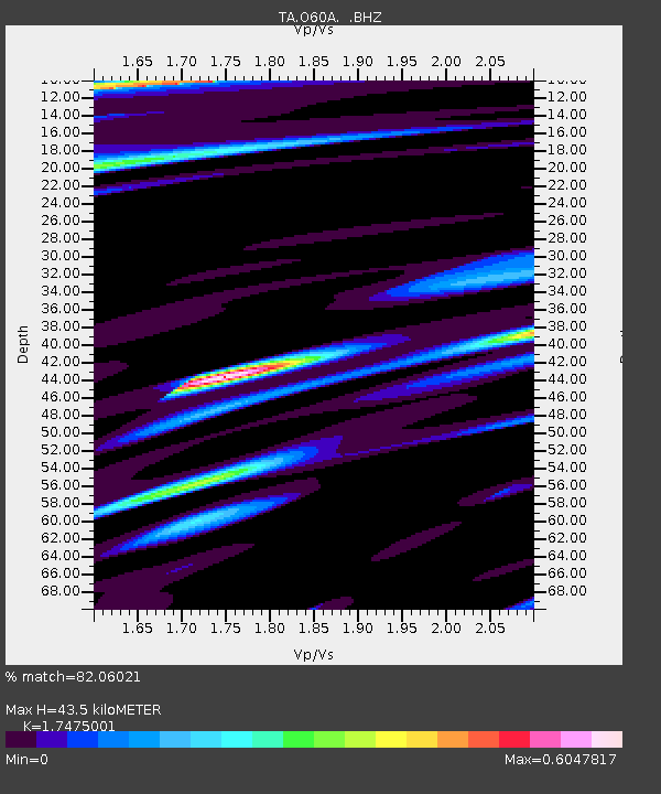
O60A Telford, PA, USA - Earthquake Result Viewer
| Earthquake location: |
Near Coast Of Ecuador |
| Earthquake latitude/longitude: |
1.6/-79.2 |
| Earthquake time(UTC): |
2014/06/16 (167) 06:39:31 GMT |
| Earthquake Depth: |
10 km |
| Earthquake Magnitude: |
5.7 MWP, 5.6 MWB |
| Earthquake Catalog/Contributor: |
NEIC PDE/NEIC COMCAT |
|
| Network: |
TA USArray Transportable Network (new EarthScope stations) |
| Station: |
O60A Telford, PA, USA |
| Lat/Lon: |
40.32 N/75.40 W |
| Elevation: |
70 m |
|
| Distance: |
38.7 deg |
| Az: |
4.678 deg |
| Baz: |
186.121 deg |
| Ray Param: |
0.07540793 |
| Estimated Moho Depth: |
43.5 km |
| Estimated Crust Vp/Vs: |
1.75 |
| Assumed Crust Vp: |
6.283 km/s |
| Estimated Crust Vs: |
3.596 km/s |
| Estimated Crust Poisson's Ratio: |
0.26 |
|
| Radial Match: |
82.06021 % |
| Radial Bump: |
396 |
| Transverse Match: |
51.66108 % |
| Transverse Bump: |
400 |
| SOD ConfigId: |
739768 |
| Insert Time: |
2014-06-30 07:13:15.778 +0000 |
| GWidth: |
2.5 |
| Max Bumps: |
400 |
| Tol: |
0.001 |
|

Signal To Noise
| Channel | StoN | STA | LTA |
| TA:O60A: :BHZ:20140616T06:46:25.150013Z | 5.335957 | 2.9481376E-7 | 5.52504E-8 |
| TA:O60A: :BHN:20140616T06:46:25.150013Z | 3.7088354 | 2.1081422E-7 | 5.684108E-8 |
| TA:O60A: :BHE:20140616T06:46:25.150013Z | 0.6707548 | 4.2168008E-8 | 6.28665E-8 |
| Arrivals |
| Ps | 5.5 SECOND |
| PpPs | 18 SECOND |
| PsPs/PpSs | 23 SECOND |


