You are here: Home > Network List > TA - USArray Transportable Network (new EarthScope stations) Stations List
> Station P54A Burton, WV, USA > Earthquake Result Viewer
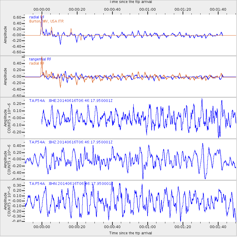
P54A Burton, WV, USA - Earthquake Result Viewer
*The percent match for this event was below the threshold and hence no stack was calculated.
| Earthquake location: |
Near Coast Of Ecuador |
| Earthquake latitude/longitude: |
1.6/-79.2 |
| Earthquake time(UTC): |
2014/06/16 (167) 06:39:31 GMT |
| Earthquake Depth: |
10 km |
| Earthquake Magnitude: |
5.7 MWP, 5.6 MWB |
| Earthquake Catalog/Contributor: |
NEIC PDE/NEIC COMCAT |
|
| Network: |
TA USArray Transportable Network (new EarthScope stations) |
| Station: |
P54A Burton, WV, USA |
| Lat/Lon: |
39.61 N/80.48 W |
| Elevation: |
473 m |
|
| Distance: |
37.9 deg |
| Az: |
358.426 deg |
| Baz: |
177.964 deg |
| Ray Param: |
$rayparam |
*The percent match for this event was below the threshold and hence was not used in the summary stack. |
|
| Radial Match: |
57.802788 % |
| Radial Bump: |
400 |
| Transverse Match: |
43.10909 % |
| Transverse Bump: |
400 |
| SOD ConfigId: |
739768 |
| Insert Time: |
2014-06-30 07:13:33.841 +0000 |
| GWidth: |
2.5 |
| Max Bumps: |
400 |
| Tol: |
0.001 |
|
Signal To Noise
| Channel | StoN | STA | LTA |
| TA:P54A: :BHZ:20140616T06:46:17.950001Z | 1.8195715 | 2.2860847E-7 | 1.2563862E-7 |
| TA:P54A: :BHN:20140616T06:46:17.950001Z | 2.705593 | 1.880344E-7 | 6.94984E-8 |
| TA:P54A: :BHE:20140616T06:46:17.950001Z | 1.1326691 | 8.738776E-8 | 7.7152066E-8 |
| Arrivals |
| Ps | |
| PpPs | |
| PsPs/PpSs | |


