You are here: Home > Network List > TA - USArray Transportable Network (new EarthScope stations) Stations List
> Station Q55A Buckhannon, WV, USA > Earthquake Result Viewer
Q55A Buckhannon, WV, USA - Earthquake Result Viewer
| Earthquake location: |
Near Coast Of Ecuador |
| Earthquake latitude/longitude: |
1.6/-79.2 |
| Earthquake time(UTC): |
2014/06/16 (167) 06:39:31 GMT |
| Earthquake Depth: |
10 km |
| Earthquake Magnitude: |
5.7 MWP, 5.6 MWB |
| Earthquake Catalog/Contributor: |
NEIC PDE/NEIC COMCAT |
|
| Network: |
TA USArray Transportable Network (new EarthScope stations) |
| Station: |
Q55A Buckhannon, WV, USA |
| Lat/Lon: |
39.00 N/80.08 W |
| Elevation: |
657 m |
|
| Distance: |
37.2 deg |
| Az: |
358.903 deg |
| Baz: |
178.593 deg |
| Ray Param: |
0.076246135 |
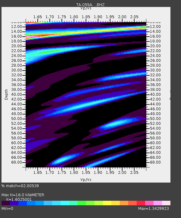
| Estimated Moho Depth: |
16.0 km |
| Estimated Crust Vp/Vs: |
1.60 |
| Assumed Crust Vp: |
6.207 km/s |
| Estimated Crust Vs: |
3.873 km/s |
| Estimated Crust Poisson's Ratio: |
0.18 |
|
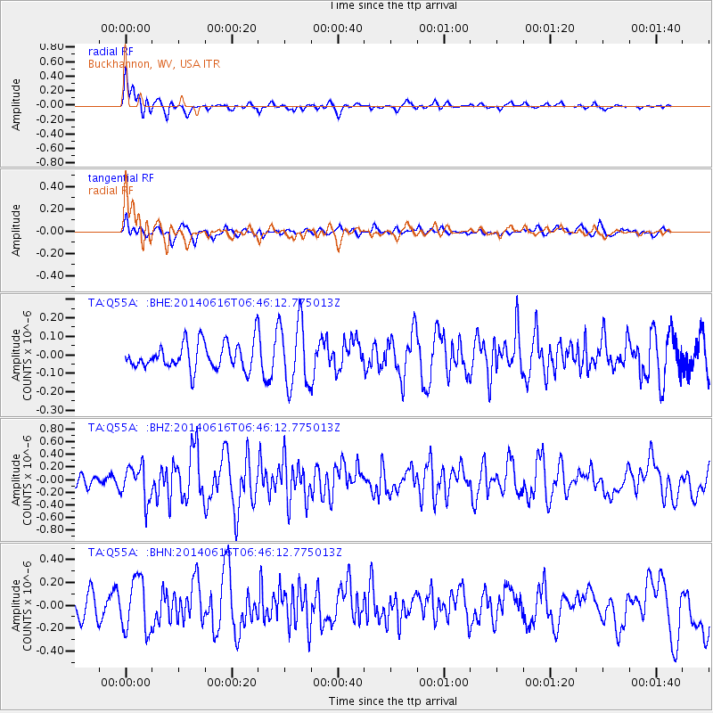
| Radial Match: |
82.80539 % |
| Radial Bump: |
400 |
| Transverse Match: |
56.635006 % |
| Transverse Bump: |
400 |
| SOD ConfigId: |
739768 |
| Insert Time: |
2014-06-30 07:14:19.554 +0000 |
| GWidth: |
2.5 |
| Max Bumps: |
400 |
| Tol: |
0.001 |
|
Signal To Noise
| Channel | StoN | STA | LTA |
| TA:Q55A: :BHZ:20140616T06:46:12.775013Z | 2.201312 | 2.7424747E-7 | 1.2458364E-7 |
| TA:Q55A: :BHN:20140616T06:46:12.775013Z | 2.770667 | 2.3279333E-7 | 8.402068E-8 |
| TA:Q55A: :BHE:20140616T06:46:12.775013Z | 2.467372 | 1.7657207E-7 | 7.156281E-8 |
| Arrivals |
| Ps | 1.7 SECOND |
| PpPs | 6.2 SECOND |
| PsPs/PpSs | 7.9 SECOND |


