You are here: Home > Network List > TA - USArray Transportable Network (new EarthScope stations) Stations List
> Station V57A Coltrane Farms, NC, USA > Earthquake Result Viewer
V57A Coltrane Farms, NC, USA - Earthquake Result Viewer
| Earthquake location: |
Near Coast Of Ecuador |
| Earthquake latitude/longitude: |
1.6/-79.2 |
| Earthquake time(UTC): |
2014/06/16 (167) 06:39:31 GMT |
| Earthquake Depth: |
10 km |
| Earthquake Magnitude: |
5.7 MWP, 5.6 MWB |
| Earthquake Catalog/Contributor: |
NEIC PDE/NEIC COMCAT |
|
| Network: |
TA USArray Transportable Network (new EarthScope stations) |
| Station: |
V57A Coltrane Farms, NC, USA |
| Lat/Lon: |
35.89 N/79.78 W |
| Elevation: |
223 m |
|
| Distance: |
34.1 deg |
| Az: |
359.209 deg |
| Baz: |
179.027 deg |
| Ray Param: |
0.07788936 |
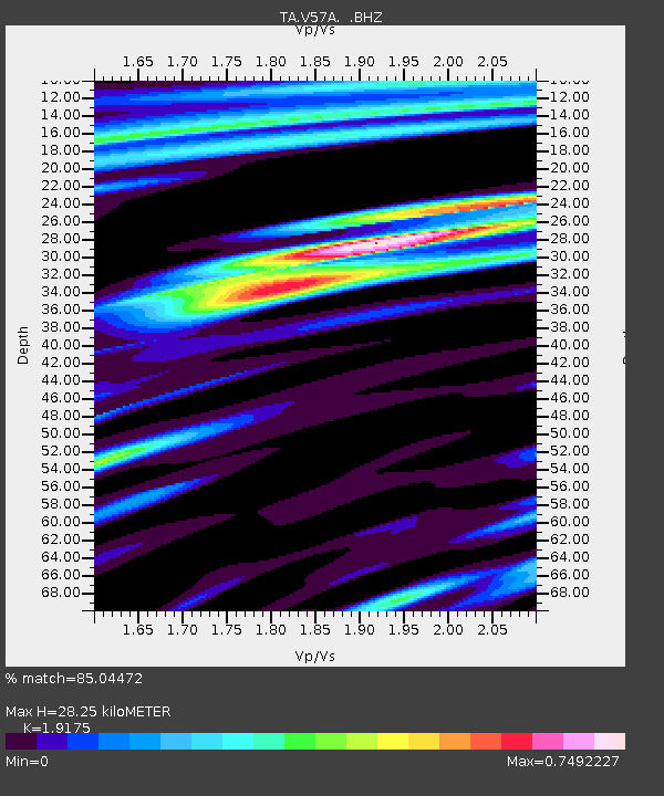
| Estimated Moho Depth: |
28.25 km |
| Estimated Crust Vp/Vs: |
1.92 |
| Assumed Crust Vp: |
6.565 km/s |
| Estimated Crust Vs: |
3.423 km/s |
| Estimated Crust Poisson's Ratio: |
0.31 |
|
| Radial Match: |
85.04472 % |
| Radial Bump: |
326 |
| Transverse Match: |
54.576454 % |
| Transverse Bump: |
400 |
| SOD ConfigId: |
739768 |
| Insert Time: |
2014-06-30 07:17:11.954 +0000 |
| GWidth: |
2.5 |
| Max Bumps: |
400 |
| Tol: |
0.001 |
|

Signal To Noise
| Channel | StoN | STA | LTA |
| TA:V57A: :BHZ:20140616T06:45:46.175007Z | 2.6614447 | 2.2202741E-7 | 8.342364E-8 |
| TA:V57A: :BHN:20140616T06:45:46.175007Z | 2.9966636 | 1.4502811E-7 | 4.839653E-8 |
| TA:V57A: :BHE:20140616T06:45:46.175007Z | 1.2947406 | 5.7021012E-8 | 4.404049E-8 |
| Arrivals |
| Ps | 4.3 SECOND |
| PpPs | 12 SECOND |
| PsPs/PpSs | 16 SECOND |


