You are here: Home > Network List > II - Global Seismograph Network (GSN - IRIS/IDA) Stations List
> Station WRAB Tennant Creek, NT, Australia > Earthquake Result Viewer
WRAB Tennant Creek, NT, Australia - Earthquake Result Viewer
| Earthquake location: |
Qinghai, China |
| Earthquake latitude/longitude: |
35.9/90.5 |
| Earthquake time(UTC): |
2001/11/14 (318) 09:26:10 GMT |
| Earthquake Depth: |
10 km |
| Earthquake Magnitude: |
6.1 MB, 8.0 MS, 7.8 MW, 7.7 MW |
| Earthquake Catalog/Contributor: |
WHDF/NEIC |
|
| Network: |
II Global Seismograph Network (GSN - IRIS/IDA) |
| Station: |
WRAB Tennant Creek, NT, Australia |
| Lat/Lon: |
19.93 S/134.36 E |
| Elevation: |
366 m |
|
| Distance: |
69.3 deg |
| Az: |
135.88 deg |
| Baz: |
323.1 deg |
| Ray Param: |
0.055709787 |
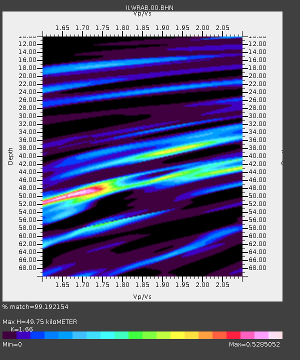
| Estimated Moho Depth: |
49.75 km |
| Estimated Crust Vp/Vs: |
1.66 |
| Assumed Crust Vp: |
6.642 km/s |
| Estimated Crust Vs: |
4.001 km/s |
| Estimated Crust Poisson's Ratio: |
0.22 |
|
| Radial Match: |
99.192154 % |
| Radial Bump: |
224 |
| Transverse Match: |
94.25678 % |
| Transverse Bump: |
400 |
| SOD ConfigId: |
20082 |
| Insert Time: |
2010-03-01 23:06:36.960 +0000 |
| GWidth: |
2.5 |
| Max Bumps: |
400 |
| Tol: |
0.001 |
|
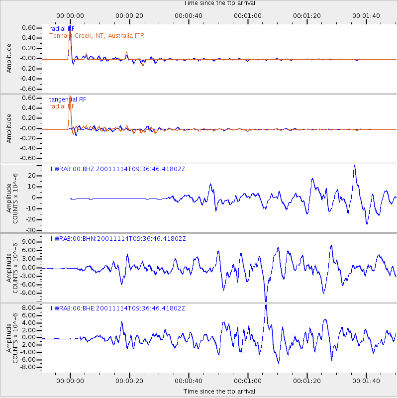
Signal To Noise
| Channel | StoN | STA | LTA |
| II:WRAB:00:BHN:20011114T09:36:46.41802Z | 3.892103 | 2.9667916E-7 | 7.622593E-8 |
| II:WRAB:00:BHE:20011114T09:36:46.41802Z | 3.3254914 | 1.6800111E-7 | 5.051918E-8 |
| II:WRAB:00:BHZ:20011114T09:36:46.41802Z | 7.067732 | 8.44121E-7 | 1.1943308E-7 |
| Arrivals |
| Ps | 5.2 SECOND |
| PpPs | 19 SECOND |
| PsPs/PpSs | 24 SECOND |


