You are here: Home > Network List > II - Global Seismograph Network (GSN - IRIS/IDA) Stations List
> Station WRAB Tennant Creek, NT, Australia > Earthquake Result Viewer
WRAB Tennant Creek, NT, Australia - Earthquake Result Viewer
| Earthquake location: |
Southern India |
| Earthquake latitude/longitude: |
23.4/70.2 |
| Earthquake time(UTC): |
2001/01/26 (026) 03:16:40 GMT |
| Earthquake Depth: |
16 km |
| Earthquake Magnitude: |
6.9 MB, 8.0 MS, 7.7 MW, 7.7 ME |
| Earthquake Catalog/Contributor: |
WHDF/NEIC |
|
| Network: |
II Global Seismograph Network (GSN - IRIS/IDA) |
| Station: |
WRAB Tennant Creek, NT, Australia |
| Lat/Lon: |
19.93 S/134.36 E |
| Elevation: |
366 m |
|
| Distance: |
75.9 deg |
| Az: |
119.224 deg |
| Baz: |
301.559 deg |
| Ray Param: |
0.05132791 |
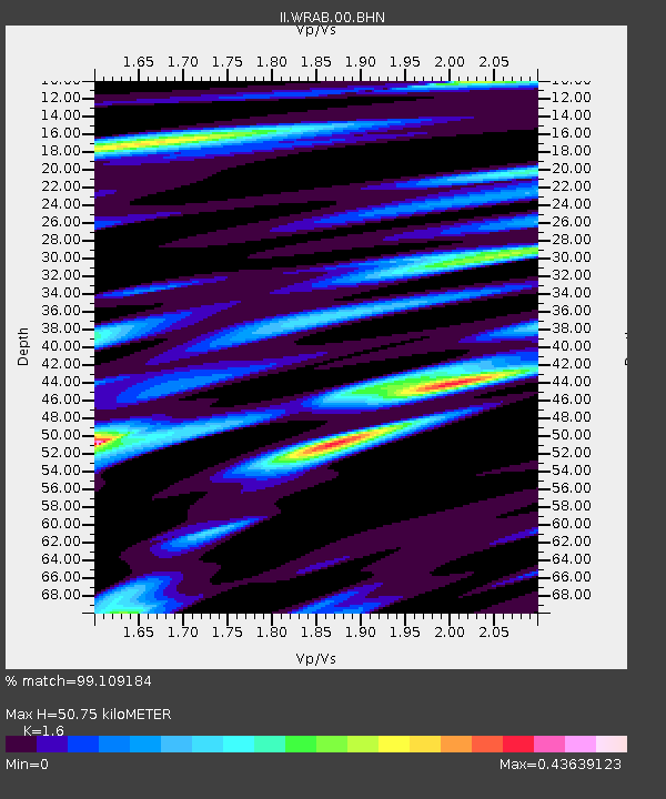
| Estimated Moho Depth: |
50.75 km |
| Estimated Crust Vp/Vs: |
1.60 |
| Assumed Crust Vp: |
6.642 km/s |
| Estimated Crust Vs: |
4.151 km/s |
| Estimated Crust Poisson's Ratio: |
0.18 |
|
| Radial Match: |
99.109184 % |
| Radial Bump: |
262 |
| Transverse Match: |
95.51729 % |
| Transverse Bump: |
400 |
| SOD ConfigId: |
3744 |
| Insert Time: |
2010-03-01 23:06:59.668 +0000 |
| GWidth: |
2.5 |
| Max Bumps: |
400 |
| Tol: |
0.001 |
|
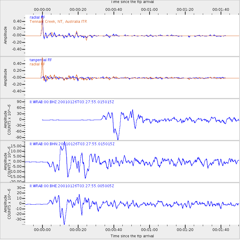
Signal To Noise
| Channel | StoN | STA | LTA |
| II:WRAB:00:BHN:20010126T03:27:55.015015Z | 12.48867 | 2.0327743E-6 | 1.6276948E-7 |
| II:WRAB:00:BHE:20010126T03:27:55.005005Z | 22.794067 | 3.0619904E-6 | 1.3433278E-7 |
| II:WRAB:00:BHZ:20010126T03:27:55.015015Z | 66.87359 | 8.755837E-6 | 1.3093118E-7 |
| Arrivals |
| Ps | 4.8 SECOND |
| PpPs | 19 SECOND |
| PsPs/PpSs | 24 SECOND |


