You are here: Home > Network List > TA - USArray Transportable Network (new EarthScope stations) Stations List
> Station T25A Trinidad, CO, USA > Earthquake Result Viewer
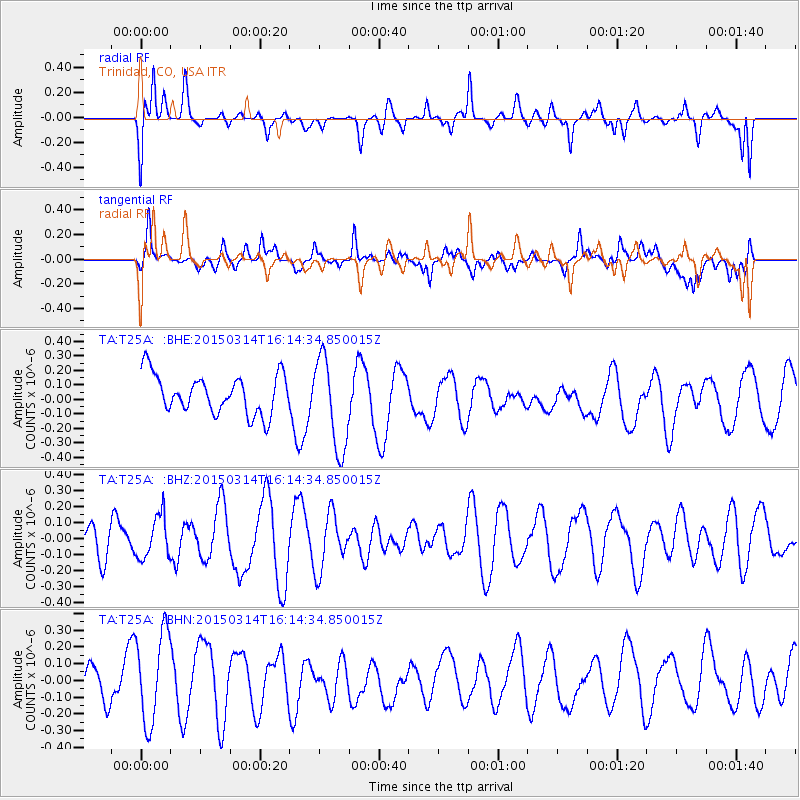
T25A Trinidad, CO, USA - Earthquake Result Viewer
*The percent match for this event was below the threshold and hence no stack was calculated.
| Earthquake location: |
Near Coast Of Northern Chile |
| Earthquake latitude/longitude: |
-27.8/-71.0 |
| Earthquake time(UTC): |
2015/03/14 (073) 16:03:46 GMT |
| Earthquake Depth: |
33 km |
| Earthquake Magnitude: |
5.1 mb |
| Earthquake Catalog/Contributor: |
ISC/ISC |
|
| Network: |
TA USArray Transportable Network (new EarthScope stations) |
| Station: |
T25A Trinidad, CO, USA |
| Lat/Lon: |
37.14 N/104.41 W |
| Elevation: |
2017 m |
|
| Distance: |
71.8 deg |
| Az: |
332.436 deg |
| Baz: |
149.13 deg |
| Ray Param: |
$rayparam |
*The percent match for this event was below the threshold and hence was not used in the summary stack. |
|
| Radial Match: |
55.07419 % |
| Radial Bump: |
310 |
| Transverse Match: |
46.45964 % |
| Transverse Bump: |
400 |
| SOD ConfigId: |
7422571 |
| Insert Time: |
2019-04-17 18:35:58.800 +0000 |
| GWidth: |
2.5 |
| Max Bumps: |
400 |
| Tol: |
0.001 |
|
Signal To Noise
| Channel | StoN | STA | LTA |
| TA:T25A: :BHZ:20150314T16:14:34.850015Z | 1.0872074 | 1.3283513E-7 | 1.2218011E-7 |
| TA:T25A: :BHN:20150314T16:14:34.850015Z | 1.6820606 | 2.720016E-7 | 1.6170738E-7 |
| TA:T25A: :BHE:20150314T16:14:34.850015Z | 2.404266 | 3.2081533E-7 | 1.3343588E-7 |
| Arrivals |
| Ps | |
| PpPs | |
| PsPs/PpSs | |


