You are here: Home > Network List > II - Global Seismograph Network (GSN - IRIS/IDA) Stations List
> Station WRAB Tennant Creek, NT, Australia > Earthquake Result Viewer
WRAB Tennant Creek, NT, Australia - Earthquake Result Viewer
| Earthquake location: |
Southern Sumatra, Indonesia |
| Earthquake latitude/longitude: |
-4.0/101.7 |
| Earthquake time(UTC): |
2001/01/16 (016) 13:25:01 GMT |
| Earthquake Depth: |
33 km |
| Earthquake Magnitude: |
6.0 MB |
| Earthquake Catalog/Contributor: |
WHDF/NEIC |
|
| Network: |
II Global Seismograph Network (GSN - IRIS/IDA) |
| Station: |
WRAB Tennant Creek, NT, Australia |
| Lat/Lon: |
19.93 S/134.36 E |
| Elevation: |
366 m |
|
| Distance: |
35.5 deg |
| Az: |
119.234 deg |
| Baz: |
292.28 deg |
| Ray Param: |
0.07711411 |
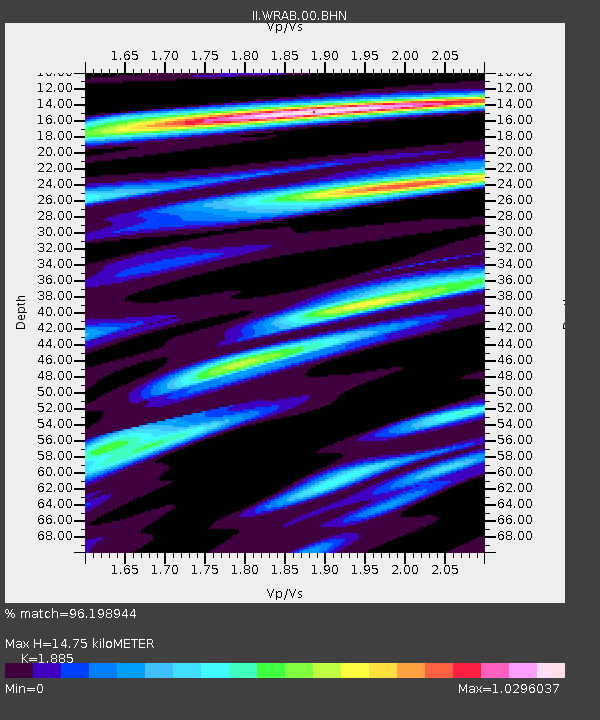
| Estimated Moho Depth: |
14.75 km |
| Estimated Crust Vp/Vs: |
1.88 |
| Assumed Crust Vp: |
6.642 km/s |
| Estimated Crust Vs: |
3.524 km/s |
| Estimated Crust Poisson's Ratio: |
0.30 |
|
| Radial Match: |
96.198944 % |
| Radial Bump: |
296 |
| Transverse Match: |
84.96708 % |
| Transverse Bump: |
400 |
| SOD ConfigId: |
3744 |
| Insert Time: |
2010-03-01 23:07:03.580 +0000 |
| GWidth: |
2.5 |
| Max Bumps: |
400 |
| Tol: |
0.001 |
|
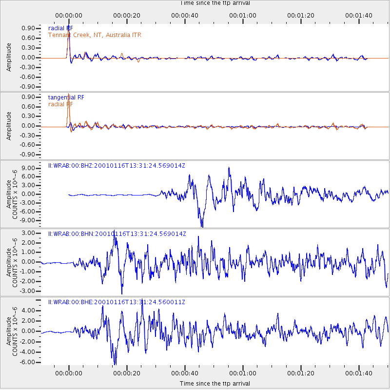
Signal To Noise
| Channel | StoN | STA | LTA |
| II:WRAB:00:BHN:20010116T13:31:24.569014Z | 2.2412102 | 1.8887135E-7 | 8.427204E-8 |
| II:WRAB:00:BHE:20010116T13:31:24.560011Z | 5.029179 | 4.4327118E-7 | 8.813986E-8 |
| II:WRAB:00:BHZ:20010116T13:31:24.569014Z | 5.9080873 | 6.2918957E-7 | 1.06496316E-7 |
| Arrivals |
| Ps | 2.1 SECOND |
| PpPs | 5.9 SECOND |
| PsPs/PpSs | 8.1 SECOND |


