You are here: Home > Network List > N4 - Central and EAstern US Network Stations List
> Station K38B Parkersburg, IA, USA > Earthquake Result Viewer
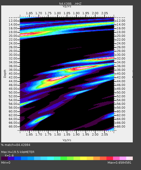
K38B Parkersburg, IA, USA - Earthquake Result Viewer
| Earthquake location: |
Northern Alaska |
| Earthquake latitude/longitude: |
67.7/-162.0 |
| Earthquake time(UTC): |
2014/06/16 (167) 12:01:11 GMT |
| Earthquake Depth: |
16 km |
| Earthquake Magnitude: |
5.7 MB, 5.5 MWP, 5.5 MI |
| Earthquake Catalog/Contributor: |
NEIC PDE/NEIC COMCAT |
|
| Network: |
N4 Central and EAstern US Network |
| Station: |
K38B Parkersburg, IA, USA |
| Lat/Lon: |
42.65 N/92.77 W |
| Elevation: |
307 m |
|
| Distance: |
43.6 deg |
| Az: |
88.693 deg |
| Baz: |
328.863 deg |
| Ray Param: |
0.07241028 |
| Estimated Moho Depth: |
19.5 km |
| Estimated Crust Vp/Vs: |
1.60 |
| Assumed Crust Vp: |
6.53 km/s |
| Estimated Crust Vs: |
4.082 km/s |
| Estimated Crust Poisson's Ratio: |
0.18 |
|
| Radial Match: |
84.42894 % |
| Radial Bump: |
400 |
| Transverse Match: |
65.64737 % |
| Transverse Bump: |
400 |
| SOD ConfigId: |
739768 |
| Insert Time: |
2014-06-30 12:30:02.356 +0000 |
| GWidth: |
2.5 |
| Max Bumps: |
400 |
| Tol: |
0.001 |
|

Signal To Noise
| Channel | StoN | STA | LTA |
| N4:K38B: :HHZ:20140616T12:08:43.709991Z | 10.91605 | 1.3162589E-6 | 1.2058014E-7 |
| N4:K38B: :HHN:20140616T12:08:43.709991Z | 5.7360053 | 5.8961007E-7 | 1.0279106E-7 |
| N4:K38B: :HHE:20140616T12:08:43.709991Z | 2.9180896 | 3.475894E-7 | 1.1911539E-7 |
| Arrivals |
| Ps | 1.9 SECOND |
| PpPs | 7.2 SECOND |
| PsPs/PpSs | 9.1 SECOND |


