You are here: Home > Network List > NM - Cooperative New Madrid Seismic Network Stations List
> Station MGMO Mountain Grove, MO > Earthquake Result Viewer
MGMO Mountain Grove, MO - Earthquake Result Viewer
| Earthquake location: |
Northern Alaska |
| Earthquake latitude/longitude: |
67.7/-162.0 |
| Earthquake time(UTC): |
2014/06/16 (167) 12:01:11 GMT |
| Earthquake Depth: |
16 km |
| Earthquake Magnitude: |
5.7 MB, 5.5 MWP, 5.5 MI |
| Earthquake Catalog/Contributor: |
NEIC PDE/NEIC COMCAT |
|
| Network: |
NM Cooperative New Madrid Seismic Network |
| Station: |
MGMO Mountain Grove, MO |
| Lat/Lon: |
37.15 N/92.27 W |
| Elevation: |
453 m |
|
| Distance: |
48.6 deg |
| Az: |
92.013 deg |
| Baz: |
331.488 deg |
| Ray Param: |
0.069247395 |
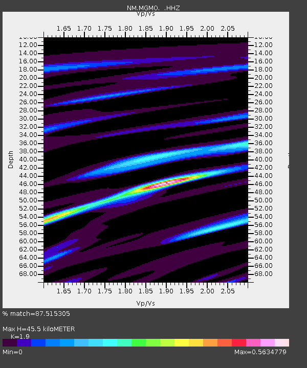
| Estimated Moho Depth: |
45.5 km |
| Estimated Crust Vp/Vs: |
1.90 |
| Assumed Crust Vp: |
6.53 km/s |
| Estimated Crust Vs: |
3.437 km/s |
| Estimated Crust Poisson's Ratio: |
0.31 |
|
| Radial Match: |
87.515305 % |
| Radial Bump: |
309 |
| Transverse Match: |
51.692574 % |
| Transverse Bump: |
400 |
| SOD ConfigId: |
739768 |
| Insert Time: |
2014-06-30 12:35:24.935 +0000 |
| GWidth: |
2.5 |
| Max Bumps: |
400 |
| Tol: |
0.001 |
|

Signal To Noise
| Channel | StoN | STA | LTA |
| NM:MGMO: :HHZ:20140616T12:09:22.65799Z | 12.649715 | 8.6397296E-7 | 6.82998E-8 |
| NM:MGMO: :HHN:20140616T12:09:22.65799Z | 7.7067666 | 4.373319E-7 | 5.6746483E-8 |
| NM:MGMO: :HHE:20140616T12:09:22.65799Z | 3.0710173 | 1.9143033E-7 | 6.23345E-8 |
| Arrivals |
| Ps | 6.6 SECOND |
| PpPs | 19 SECOND |
| PsPs/PpSs | 26 SECOND |


