You are here: Home > Network List > TA - USArray Transportable Network (new EarthScope stations) Stations List
> Station D58A Chemin du LacGrosbois, Trois-Rives, QC, CAN > Earthquake Result Viewer
D58A Chemin du LacGrosbois, Trois-Rives, QC, CAN - Earthquake Result Viewer
| Earthquake location: |
Northern Alaska |
| Earthquake latitude/longitude: |
67.7/-162.0 |
| Earthquake time(UTC): |
2014/06/16 (167) 12:01:11 GMT |
| Earthquake Depth: |
16 km |
| Earthquake Magnitude: |
5.7 MB, 5.5 MWP, 5.5 MI |
| Earthquake Catalog/Contributor: |
NEIC PDE/NEIC COMCAT |
|
| Network: |
TA USArray Transportable Network (new EarthScope stations) |
| Station: |
D58A Chemin du LacGrosbois, Trois-Rives, QC, CAN |
| Lat/Lon: |
47.10 N/72.88 W |
| Elevation: |
398 m |
|
| Distance: |
47.2 deg |
| Az: |
68.513 deg |
| Baz: |
328.686 deg |
| Ray Param: |
0.07010733 |
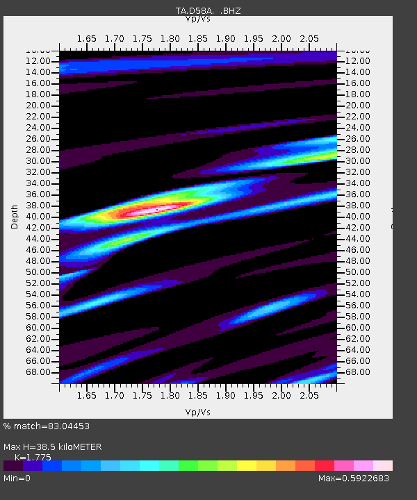
| Estimated Moho Depth: |
38.5 km |
| Estimated Crust Vp/Vs: |
1.77 |
| Assumed Crust Vp: |
6.61 km/s |
| Estimated Crust Vs: |
3.724 km/s |
| Estimated Crust Poisson's Ratio: |
0.27 |
|
| Radial Match: |
83.04453 % |
| Radial Bump: |
394 |
| Transverse Match: |
67.61695 % |
| Transverse Bump: |
400 |
| SOD ConfigId: |
739768 |
| Insert Time: |
2014-06-30 12:41:49.390 +0000 |
| GWidth: |
2.5 |
| Max Bumps: |
400 |
| Tol: |
0.001 |
|
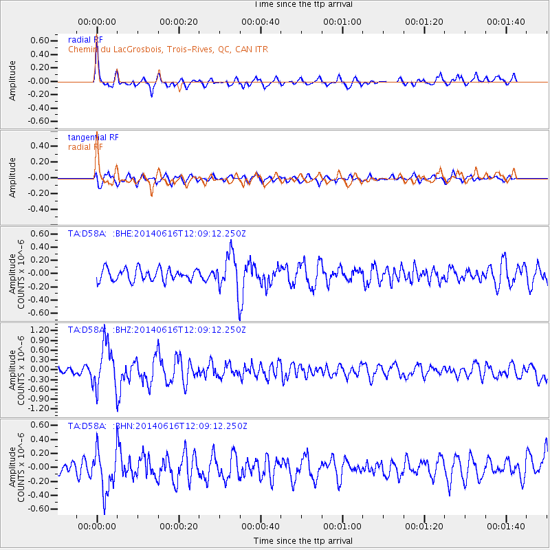
Signal To Noise
| Channel | StoN | STA | LTA |
| TA:D58A: :BHZ:20140616T12:09:12.250Z | 6.2498026 | 6.98203E-7 | 1.1171601E-7 |
| TA:D58A: :BHN:20140616T12:09:12.250Z | 3.2019804 | 3.0558016E-7 | 9.543474E-8 |
| TA:D58A: :BHE:20140616T12:09:12.250Z | 3.1829257 | 2.8690923E-7 | 9.01401E-8 |
| Arrivals |
| Ps | 4.8 SECOND |
| PpPs | 15 SECOND |
| PsPs/PpSs | 20 SECOND |


