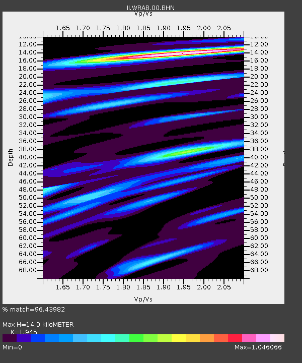
WRAB Tennant Creek, NT, Australia - Earthquake Result Viewer
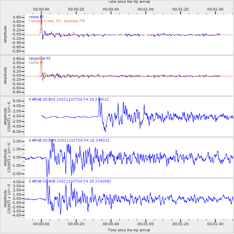
Earthquake location: Northern Sumatra, Indonesia
Earthquake latitude/longitude: 3.0/96.4
Earthquake time(UTC): 2002/11/02 (306) 09:46:46 GMT
Earthquake Depth: 27 km
Earthquake Magnitude: 5.9 MB, 6.4 MS, 6.4 MW, 6.1 MW
Earthquake Catalog/Contributor: WHDF/NEIC
Network: II Global Seismograph Network (GSN - IRIS/IDA)
Station: WRAB Tennant Creek, NT, Australia
Lat/Lon: 19.93 S/134.36 E
Elevation: 366 m
Distance: 43.7 deg
Az: 123.04 deg
Baz: 297.144 deg
Ray Param: 0.072356194
Estimated Moho Depth: 14.0 km
Estimated Crust Vp/Vs: 1.95
Assumed Crust Vp: 6.642 km/s
Estimated Crust Vs: 3.415 km/s
Estimated Crust Poisson's Ratio: 0.32
Radial Match: 96.43982 %
Radial Bump: 329
Transverse Match: 80.491066 %
Transverse Bump: 400
SOD ConfigId: 4714
Insert Time: 2010-03-01 23:08:01.741 +0000
GWidth: 2.5
Max Bumps: 400
Tol: 0.001

Signal To Noise

ChannelStoNSTALTA
II:WRAB:00:BHN:20021102T09:54:18.34801Z4.31132468.499765E-71.9714975E-7
II:WRAB:00:BHE:20021102T09:54:18.339008Z11.5369011.5669782E-61.3582314E-7
II:WRAB:00:BHZ:20021102T09:54:18.34801Z13.3645462.6506132E-61.983317E-7
Arrivals
Ps2.1 SECOND
PpPs5.8 SECOND
PsPs/PpSs7.9 SECOND