You are here: Home > Network List > TA - USArray Transportable Network (new EarthScope stations) Stations List
> Station G47A Hillman, MI, USA > Earthquake Result Viewer
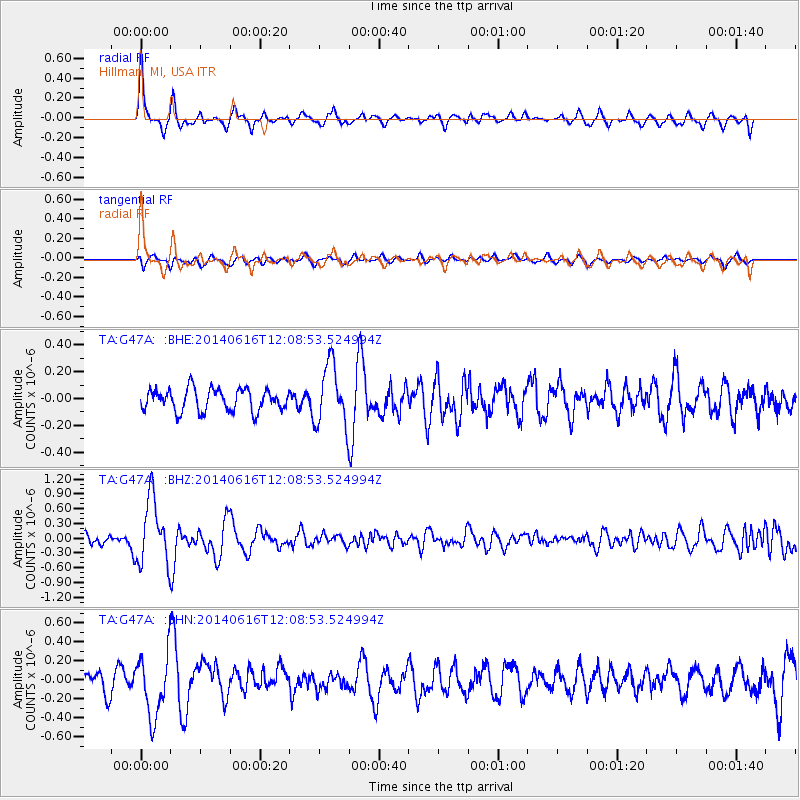
G47A Hillman, MI, USA - Earthquake Result Viewer
*The percent match for this event was below the threshold and hence no stack was calculated.
| Earthquake location: |
Northern Alaska |
| Earthquake latitude/longitude: |
67.7/-162.0 |
| Earthquake time(UTC): |
2014/06/16 (167) 12:01:11 GMT |
| Earthquake Depth: |
16 km |
| Earthquake Magnitude: |
5.7 MB, 5.5 MWP, 5.5 MI |
| Earthquake Catalog/Contributor: |
NEIC PDE/NEIC COMCAT |
|
| Network: |
TA USArray Transportable Network (new EarthScope stations) |
| Station: |
G47A Hillman, MI, USA |
| Lat/Lon: |
45.17 N/83.86 W |
| Elevation: |
239 m |
|
| Distance: |
44.9 deg |
| Az: |
78.931 deg |
| Baz: |
328.031 deg |
| Ray Param: |
$rayparam |
*The percent match for this event was below the threshold and hence was not used in the summary stack. |
|
| Radial Match: |
74.18414 % |
| Radial Bump: |
400 |
| Transverse Match: |
59.01996 % |
| Transverse Bump: |
400 |
| SOD ConfigId: |
739768 |
| Insert Time: |
2014-06-30 12:44:10.942 +0000 |
| GWidth: |
2.5 |
| Max Bumps: |
400 |
| Tol: |
0.001 |
|
Signal To Noise
| Channel | StoN | STA | LTA |
| TA:G47A: :BHZ:20140616T12:08:53.524994Z | 5.4734316 | 6.6257013E-7 | 1.2105205E-7 |
| TA:G47A: :BHN:20140616T12:08:53.524994Z | 2.7721822 | 3.2500708E-7 | 1.1723871E-7 |
| TA:G47A: :BHE:20140616T12:08:53.524994Z | 2.8164163 | 2.2944717E-7 | 8.1467775E-8 |
| Arrivals |
| Ps | |
| PpPs | |
| PsPs/PpSs | |


