You are here: Home > Network List > TA - USArray Transportable Network (new EarthScope stations) Stations List
> Station Q57A Strasburg, VA, USA > Earthquake Result Viewer
Q57A Strasburg, VA, USA - Earthquake Result Viewer
| Earthquake location: |
Northern Alaska |
| Earthquake latitude/longitude: |
67.7/-162.0 |
| Earthquake time(UTC): |
2014/06/16 (167) 12:01:11 GMT |
| Earthquake Depth: |
16 km |
| Earthquake Magnitude: |
5.7 MB, 5.5 MWP, 5.5 MI |
| Earthquake Catalog/Contributor: |
NEIC PDE/NEIC COMCAT |
|
| Network: |
TA USArray Transportable Network (new EarthScope stations) |
| Station: |
Q57A Strasburg, VA, USA |
| Lat/Lon: |
39.04 N/78.41 W |
| Elevation: |
324 m |
|
| Distance: |
52.2 deg |
| Az: |
78.392 deg |
| Baz: |
331.317 deg |
| Ray Param: |
0.06689974 |
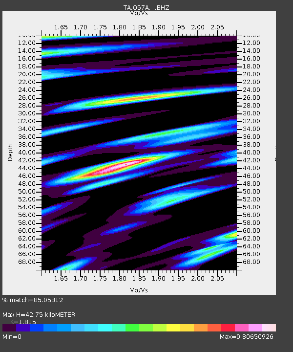
| Estimated Moho Depth: |
42.75 km |
| Estimated Crust Vp/Vs: |
1.82 |
| Assumed Crust Vp: |
6.159 km/s |
| Estimated Crust Vs: |
3.393 km/s |
| Estimated Crust Poisson's Ratio: |
0.28 |
|
| Radial Match: |
85.05812 % |
| Radial Bump: |
400 |
| Transverse Match: |
62.319897 % |
| Transverse Bump: |
400 |
| SOD ConfigId: |
739768 |
| Insert Time: |
2014-06-30 12:54:16.657 +0000 |
| GWidth: |
2.5 |
| Max Bumps: |
400 |
| Tol: |
0.001 |
|

Signal To Noise
| Channel | StoN | STA | LTA |
| TA:Q57A: :BHZ:20140616T12:09:49.924988Z | 9.828327 | 5.7092495E-7 | 5.808974E-8 |
| TA:Q57A: :BHN:20140616T12:09:49.924988Z | 5.7992206 | 2.7181173E-7 | 4.687039E-8 |
| TA:Q57A: :BHE:20140616T12:09:49.924988Z | 2.8995235 | 1.4144211E-7 | 4.8781157E-8 |
| Arrivals |
| Ps | 5.9 SECOND |
| PpPs | 19 SECOND |
| PsPs/PpSs | 25 SECOND |


