You are here: Home > Network List > TA - USArray Transportable Network (new EarthScope stations) Stations List
> Station S53A Williamson, WV, USA > Earthquake Result Viewer
S53A Williamson, WV, USA - Earthquake Result Viewer
| Earthquake location: |
Northern Alaska |
| Earthquake latitude/longitude: |
67.7/-162.0 |
| Earthquake time(UTC): |
2014/06/16 (167) 12:01:11 GMT |
| Earthquake Depth: |
16 km |
| Earthquake Magnitude: |
5.7 MB, 5.5 MWP, 5.5 MI |
| Earthquake Catalog/Contributor: |
NEIC PDE/NEIC COMCAT |
|
| Network: |
TA USArray Transportable Network (new EarthScope stations) |
| Station: |
S53A Williamson, WV, USA |
| Lat/Lon: |
37.68 N/82.13 W |
| Elevation: |
564 m |
|
| Distance: |
52.0 deg |
| Az: |
82.463 deg |
| Baz: |
331.522 deg |
| Ray Param: |
0.06703776 |
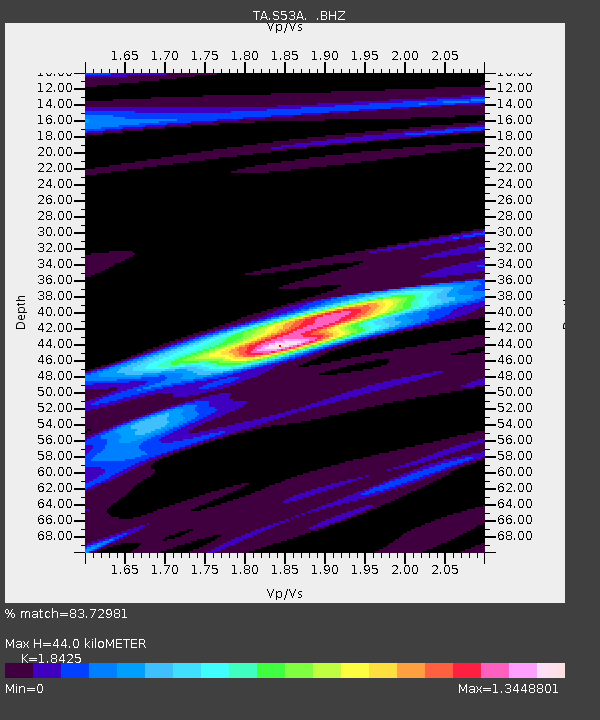
| Estimated Moho Depth: |
44.0 km |
| Estimated Crust Vp/Vs: |
1.84 |
| Assumed Crust Vp: |
6.476 km/s |
| Estimated Crust Vs: |
3.515 km/s |
| Estimated Crust Poisson's Ratio: |
0.29 |
|
| Radial Match: |
83.72981 % |
| Radial Bump: |
400 |
| Transverse Match: |
45.328304 % |
| Transverse Bump: |
400 |
| SOD ConfigId: |
739768 |
| Insert Time: |
2014-06-30 12:55:11.457 +0000 |
| GWidth: |
2.5 |
| Max Bumps: |
400 |
| Tol: |
0.001 |
|

Signal To Noise
| Channel | StoN | STA | LTA |
| TA:S53A: :BHZ:20140616T12:09:48.349976Z | 9.064458 | 9.381675E-7 | 1.0349957E-7 |
| TA:S53A: :BHN:20140616T12:09:48.349976Z | 2.0115228 | 5.679637E-7 | 2.823551E-7 |
| TA:S53A: :BHE:20140616T12:09:48.349976Z | 1.048377 | 3.624856E-7 | 3.4575882E-7 |
| Arrivals |
| Ps | 6.0 SECOND |
| PpPs | 18 SECOND |
| PsPs/PpSs | 24 SECOND |


