You are here: Home > Network List > TA - USArray Transportable Network (new EarthScope stations) Stations List
> Station S54A Dingess, Beckley, WV, USA > Earthquake Result Viewer
S54A Dingess, Beckley, WV, USA - Earthquake Result Viewer

| Earthquake location: |
Northern Alaska |
| Earthquake latitude/longitude: |
67.7/-162.0 |
| Earthquake time(UTC): |
2014/06/16 (167) 12:01:11 GMT |
| Earthquake Depth: |
16 km |
| Earthquake Magnitude: |
5.7 MB, 5.5 MWP, 5.5 MI |
| Earthquake Catalog/Contributor: |
NEIC PDE/NEIC COMCAT |
|
| Network: |
TA USArray Transportable Network (new EarthScope stations) |
| Station: |
S54A Dingess, Beckley, WV, USA |
| Lat/Lon: |
37.80 N/81.31 W |
| Elevation: |
636 m |
|
| Distance: |
52.2 deg |
| Az: |
81.672 deg |
| Baz: |
331.532 deg |
| Ray Param: |
0.066904046 |
| Estimated Moho Depth: |
17.25 km |
| Estimated Crust Vp/Vs: |
1.69 |
| Assumed Crust Vp: |
6.159 km/s |
| Estimated Crust Vs: |
3.639 km/s |
| Estimated Crust Poisson's Ratio: |
0.23 |
|
| Radial Match: |
80.21694 % |
| Radial Bump: |
392 |
| Transverse Match: |
56.96365 % |
| Transverse Bump: |
400 |
| SOD ConfigId: |
739768 |
| Insert Time: |
2014-06-30 12:55:16.112 +0000 |
| GWidth: |
2.5 |
| Max Bumps: |
400 |
| Tol: |
0.001 |
|
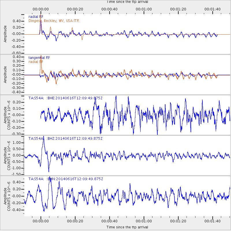
Signal To Noise
| Channel | StoN | STA | LTA |
| TA:S54A: :BHZ:20140616T12:09:49.875Z | 8.036023 | 7.141597E-7 | 8.886979E-8 |
| TA:S54A: :BHN:20140616T12:09:49.875Z | 2.7641423 | 2.6152122E-7 | 9.461207E-8 |
| TA:S54A: :BHE:20140616T12:09:49.875Z | 2.685181 | 1.5504304E-7 | 5.7740262E-8 |
| Arrivals |
| Ps | 2.0 SECOND |
| PpPs | 7.2 SECOND |
| PsPs/PpSs | 9.2 SECOND |


