You are here: Home > Network List > TA - USArray Transportable Network (new EarthScope stations) Stations List
> Station S55A Lewisburg, WV, USA > Earthquake Result Viewer
S55A Lewisburg, WV, USA - Earthquake Result Viewer
| Earthquake location: |
Northern Alaska |
| Earthquake latitude/longitude: |
67.7/-162.0 |
| Earthquake time(UTC): |
2014/06/16 (167) 12:01:11 GMT |
| Earthquake Depth: |
16 km |
| Earthquake Magnitude: |
5.7 MB, 5.5 MWP, 5.5 MI |
| Earthquake Catalog/Contributor: |
NEIC PDE/NEIC COMCAT |
|
| Network: |
TA USArray Transportable Network (new EarthScope stations) |
| Station: |
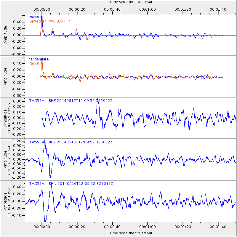
S55A Lewisburg, WV, USA |
| Lat/Lon: |
37.77 N/80.50 W |
| Elevation: |
647 m |
|
| Distance: |
52.5 deg |
| Az: |
80.975 deg |
| Baz: |
331.601 deg |
| Ray Param: |
0.06669326 |
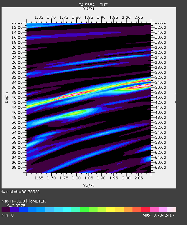
| Estimated Moho Depth: |
35.0 km |
| Estimated Crust Vp/Vs: |
2.08 |
| Assumed Crust Vp: |
6.159 km/s |
| Estimated Crust Vs: |
2.964 km/s |
| Estimated Crust Poisson's Ratio: |
0.35 |
|
| Radial Match: |
88.78931 % |
| Radial Bump: |
400 |
| Transverse Match: |
56.79948 % |
| Transverse Bump: |
400 |
| SOD ConfigId: |
739768 |
| Insert Time: |
2014-06-30 12:55:18.909 +0000 |
| GWidth: |
2.5 |
| Max Bumps: |
400 |
| Tol: |
0.001 |
|
Signal To Noise
| Channel | StoN | STA | LTA |
| TA:S55A: :BHZ:20140616T12:09:52.325012Z | 9.410137 | 7.0107683E-7 | 7.4502296E-8 |
| TA:S55A: :BHN:20140616T12:09:52.325012Z | 7.1144342 | 3.3614856E-7 | 4.724881E-8 |
| TA:S55A: :BHE:20140616T12:09:52.325012Z | 2.7717245 | 1.701339E-7 | 6.138197E-8 |
| Arrivals |
| Ps | 6.4 SECOND |
| PpPs | 17 SECOND |
| PsPs/PpSs | 23 SECOND |


