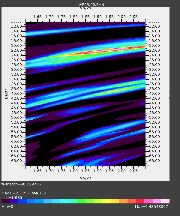
WRAB Tennant Creek, NT, Australia - Earthquake Result Viewer
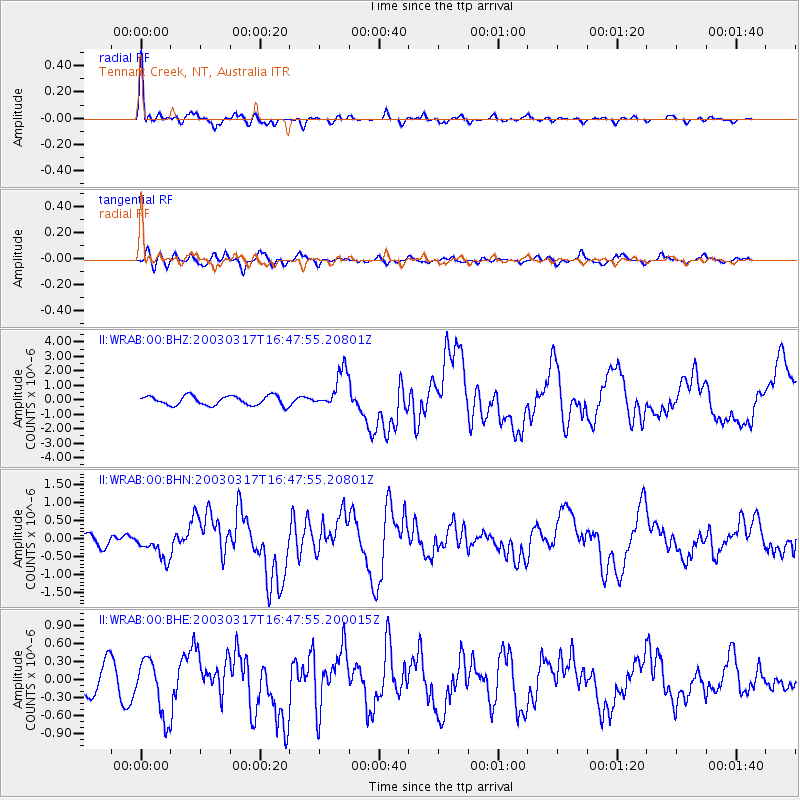
Earthquake location: Rat Islands, Aleutian Islands
Earthquake latitude/longitude: 51.3/178.0
Earthquake time(UTC): 2003/03/17 (076) 16:36:17 GMT
Earthquake Depth: 33 km
Earthquake Magnitude: 5.9 MB, 6.7 MS, 7.0 MW, 7.0 MW
Earthquake Catalog/Contributor: WHDF/NEIC
Network: II Global Seismograph Network (GSN - IRIS/IDA)
Station: WRAB Tennant Creek, NT, Australia
Lat/Lon: 19.93 S/134.36 E
Elevation: 366 m
Distance: 80.6 deg
Az: 221.143 deg
Baz: 26.06 deg
Ray Param: 0.048154913
Estimated Moho Depth: 21.75 km
Estimated Crust Vp/Vs: 1.93
Assumed Crust Vp: 6.642 km/s
Estimated Crust Vs: 3.433 km/s
Estimated Crust Poisson's Ratio: 0.32
Radial Match: 96.229706 %
Radial Bump: 398
Transverse Match: 77.96922 %
Transverse Bump: 400
SOD ConfigId: 4714
Insert Time: 2010-03-01 23:08:46.617 +0000
GWidth: 2.5
Max Bumps: 400
Tol: 0.001

Signal To Noise

ChannelStoNSTALTA
II:WRAB:00:BHN:20030317T16:47:55.20801Z2.39828473.730458E-71.5554693E-7
II:WRAB:00:BHE:20030317T16:47:55.200015Z2.93329124.778293E-71.6289869E-7
II:WRAB:00:BHZ:20030317T16:47:55.20801Z4.1290031.3251721E-63.209424E-7
Arrivals
Ps3.1 SECOND
PpPs9.4 SECOND
PsPs/PpSs12 SECOND