You are here: Home > Network List > TA - USArray Transportable Network (new EarthScope stations) Stations List
> Station V55A Taylorsville, NC, USA > Earthquake Result Viewer
V55A Taylorsville, NC, USA - Earthquake Result Viewer
| Earthquake location: |
Northern Alaska |
| Earthquake latitude/longitude: |
67.7/-162.0 |
| Earthquake time(UTC): |
2014/06/16 (167) 12:01:11 GMT |
| Earthquake Depth: |
16 km |
| Earthquake Magnitude: |
5.7 MB, 5.5 MWP, 5.5 MI |
| Earthquake Catalog/Contributor: |
NEIC PDE/NEIC COMCAT |
|
| Network: |
TA USArray Transportable Network (new EarthScope stations) |
| Station: |
V55A Taylorsville, NC, USA |
| Lat/Lon: |
35.85 N/81.21 W |
| Elevation: |
306 m |
|
| Distance: |
53.9 deg |
| Az: |
82.733 deg |
| Baz: |
332.228 deg |
| Ray Param: |
0.065748125 |
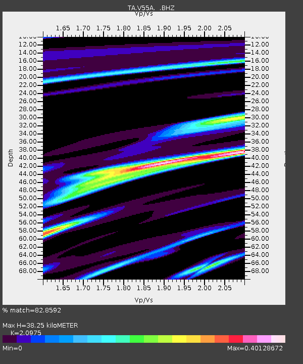
| Estimated Moho Depth: |
38.25 km |
| Estimated Crust Vp/Vs: |
2.10 |
| Assumed Crust Vp: |
6.419 km/s |
| Estimated Crust Vs: |
3.06 km/s |
| Estimated Crust Poisson's Ratio: |
0.35 |
|
| Radial Match: |
82.8592 % |
| Radial Bump: |
370 |
| Transverse Match: |
69.678375 % |
| Transverse Bump: |
400 |
| SOD ConfigId: |
739768 |
| Insert Time: |
2014-06-30 12:57:17.162 +0000 |
| GWidth: |
2.5 |
| Max Bumps: |
400 |
| Tol: |
0.001 |
|

Signal To Noise
| Channel | StoN | STA | LTA |
| TA:V55A: :BHZ:20140616T12:10:02.750Z | 8.847977 | 5.977513E-7 | 6.755797E-8 |
| TA:V55A: :BHN:20140616T12:10:02.750Z | 6.953338 | 2.6778366E-7 | 3.8511526E-8 |
| TA:V55A: :BHE:20140616T12:10:02.750Z | 3.5004203 | 1.418087E-7 | 4.0511907E-8 |
| Arrivals |
| Ps | 6.8 SECOND |
| PpPs | 18 SECOND |
| PsPs/PpSs | 24 SECOND |


