You are here: Home > Network List > CI - Caltech Regional Seismic Network Stations List
> Station VCS Vincent Substation, Palmdale, CA, USA > Earthquake Result Viewer
VCS Vincent Substation, Palmdale, CA, USA - Earthquake Result Viewer
| Earthquake location: |
Panama-Costa Rica Border Region |
| Earthquake latitude/longitude: |
8.3/-83.0 |
| Earthquake time(UTC): |
2008/11/19 (324) 06:11:20 GMT |
| Earthquake Depth: |
32 km |
| Earthquake Magnitude: |
5.9 MB, 5.9 MS, 6.2 MW, 6.1 MW |
| Earthquake Catalog/Contributor: |
WHDF/NEIC |
|
| Network: |
CI Caltech Regional Seismic Network |
| Station: |
VCS Vincent Substation, Palmdale, CA, USA |
| Lat/Lon: |
34.48 N/118.12 W |
| Elevation: |
991 m |
|
| Distance: |
41.5 deg |
| Az: |
314.128 deg |
| Baz: |
120.681 deg |
| Ray Param: |
0.07369087 |
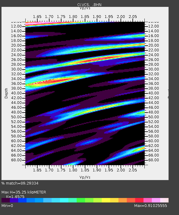
| Estimated Moho Depth: |
35.25 km |
| Estimated Crust Vp/Vs: |
1.66 |
| Assumed Crust Vp: |
6.1 km/s |
| Estimated Crust Vs: |
3.68 km/s |
| Estimated Crust Poisson's Ratio: |
0.21 |
|
| Radial Match: |
89.29334 % |
| Radial Bump: |
400 |
| Transverse Match: |
86.02701 % |
| Transverse Bump: |
400 |
| SOD ConfigId: |
2658 |
| Insert Time: |
2010-02-25 21:08:20.266 +0000 |
| GWidth: |
2.5 |
| Max Bumps: |
400 |
| Tol: |
0.001 |
|

Signal To Noise
| Channel | StoN | STA | LTA |
| CI:VCS: :BHN:20081119T06:18:34.36901Z | 4.1844172 | 4.7553866E-7 | 1.13645136E-7 |
| CI:VCS: :BHE:20081119T06:18:34.36901Z | 1.2042753 | 1.4979226E-7 | 1.2438373E-7 |
| CI:VCS: :BHZ:20081119T06:18:34.36901Z | 1.973818 | 2.3983927E-7 | 1.2151033E-7 |
| Arrivals |
| Ps | 4.1 SECOND |
| PpPs | 14 SECOND |
| PsPs/PpSs | 18 SECOND |


