You are here: Home > Network List > TO - Tectonic Observatory Stations List
> Station CC36 CCSE CC36 > Earthquake Result Viewer
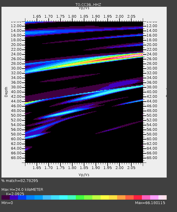
CC36 CCSE CC36 - Earthquake Result Viewer
| Earthquake location: |
Mariana Islands |
| Earthquake latitude/longitude: |
18.7/146.4 |
| Earthquake time(UTC): |
2015/03/15 (074) 04:47:21 GMT |
| Earthquake Depth: |
58 km |
| Earthquake Magnitude: |
5.8 MO |
| Earthquake Catalog/Contributor: |
NEIC PDE/NEIC ALERT |
|
| Network: |
TO Tectonic Observatory |
| Station: |
CC36 CCSE CC36 |
| Lat/Lon: |
36.39 N/118.96 W |
| Elevation: |
265 m |
|
| Distance: |
82.7 deg |
| Az: |
54.177 deg |
| Baz: |
287.757 deg |
| Ray Param: |
0.04659195 |
| Estimated Moho Depth: |
24.0 km |
| Estimated Crust Vp/Vs: |
2.09 |
| Assumed Crust Vp: |
6.291 km/s |
| Estimated Crust Vs: |
3.007 km/s |
| Estimated Crust Poisson's Ratio: |
0.35 |
|
| Radial Match: |
82.78295 % |
| Radial Bump: |
400 |
| Transverse Match: |
66.05709 % |
| Transverse Bump: |
400 |
| SOD ConfigId: |
7422571 |
| Insert Time: |
2019-04-17 18:51:34.433 +0000 |
| GWidth: |
2.5 |
| Max Bumps: |
400 |
| Tol: |
0.001 |
|

Signal To Noise
| Channel | StoN | STA | LTA |
| TO:CC36: :HHZ:20150315T04:59:07.350024Z | 2.3560534 | 2.2663011E-9 | 9.619057E-10 |
| TO:CC36: :HHN:20150315T04:59:07.350024Z | 1.2440546 | 1.5327046E-7 | 1.2320237E-7 |
| TO:CC36: :HHE:20150315T04:59:07.350024Z | 1.0776561 | 1.5271057E-7 | 1.4170621E-7 |
| Arrivals |
| Ps | 4.3 SECOND |
| PpPs | 12 SECOND |
| PsPs/PpSs | 16 SECOND |


