You are here: Home > Network List > UW - Pacific Northwest Regional Seismic Network Stations List
> Station UMAT Pilot Rock, OR, USA > Earthquake Result Viewer
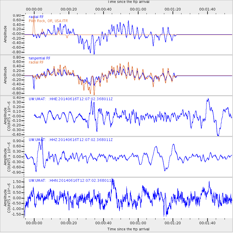
UMAT Pilot Rock, OR, USA - Earthquake Result Viewer
*The percent match for this event was below the threshold and hence no stack was calculated.
| Earthquake location: |
Northern Alaska |
| Earthquake latitude/longitude: |
67.7/-162.0 |
| Earthquake time(UTC): |
2014/06/16 (167) 12:01:11 GMT |
| Earthquake Depth: |
16 km |
| Earthquake Magnitude: |
5.7 MB, 5.5 MWP, 5.5 MI |
| Earthquake Catalog/Contributor: |
NEIC PDE/NEIC COMCAT |
|
| Network: |
UW Pacific Northwest Regional Seismic Network |
| Station: |
UMAT Pilot Rock, OR, USA |
| Lat/Lon: |
45.29 N/118.96 W |
| Elevation: |
1318 m |
|
| Distance: |
31.6 deg |
| Az: |
113.209 deg |
| Baz: |
330.208 deg |
| Ray Param: |
$rayparam |
*The percent match for this event was below the threshold and hence was not used in the summary stack. |
|
| Radial Match: |
23.592434 % |
| Radial Bump: |
400 |
| Transverse Match: |
35.089725 % |
| Transverse Bump: |
400 |
| SOD ConfigId: |
739768 |
| Insert Time: |
2014-06-30 13:06:15.634 +0000 |
| GWidth: |
2.5 |
| Max Bumps: |
400 |
| Tol: |
0.001 |
|
Signal To Noise
| Channel | StoN | STA | LTA |
| UW:UMAT: :HHZ:20140616T12:07:02.368011Z | 9.917007 | 5.869703E-7 | 5.9188253E-8 |
| UW:UMAT: :HHN:20140616T12:07:02.368011Z | 0.5542634 | 4.191044E-7 | 7.561466E-7 |
| UW:UMAT: :HHE:20140616T12:07:02.368011Z | 2.6258988 | 1.6938046E-7 | 6.45038E-8 |
| Arrivals |
| Ps | |
| PpPs | |
| PsPs/PpSs | |


