You are here: Home > Network List > TA - USArray Transportable Network (new EarthScope stations) Stations List
> Station D46A Sault St. Marie, ON, CAN > Earthquake Result Viewer
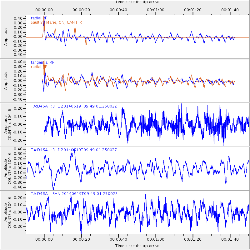
D46A Sault St. Marie, ON, CAN - Earthquake Result Viewer
*The percent match for this event was below the threshold and hence no stack was calculated.
| Earthquake location: |
Near Coast Of Northern Chile |
| Earthquake latitude/longitude: |
-20.0/-70.9 |
| Earthquake time(UTC): |
2014/06/19 (170) 09:38:37 GMT |
| Earthquake Depth: |
19 km |
| Earthquake Magnitude: |
5.7 MWP |
| Earthquake Catalog/Contributor: |
NEIC PDE/NEIC COMCAT |
|
| Network: |
TA USArray Transportable Network (new EarthScope stations) |
| Station: |
D46A Sault St. Marie, ON, CAN |
| Lat/Lon: |
46.89 N/84.04 W |
| Elevation: |
353 m |
|
| Distance: |
67.6 deg |
| Az: |
350.323 deg |
| Baz: |
166.67 deg |
| Ray Param: |
$rayparam |
*The percent match for this event was below the threshold and hence was not used in the summary stack. |
|
| Radial Match: |
63.427177 % |
| Radial Bump: |
400 |
| Transverse Match: |
50.54868 % |
| Transverse Bump: |
400 |
| SOD ConfigId: |
739768 |
| Insert Time: |
2014-07-03 10:08:00.460 +0000 |
| GWidth: |
2.5 |
| Max Bumps: |
400 |
| Tol: |
0.001 |
|
Signal To Noise
| Channel | StoN | STA | LTA |
| TA:D46A: :BHZ:20140619T09:49:01.25002Z | 1.9616301 | 1.819329E-7 | 9.274577E-8 |
| TA:D46A: :BHN:20140619T09:49:01.25002Z | 2.1523166 | 1.2017313E-7 | 5.5834317E-8 |
| TA:D46A: :BHE:20140619T09:49:01.25002Z | 0.73286766 | 4.7466646E-8 | 6.476837E-8 |
| Arrivals |
| Ps | |
| PpPs | |
| PsPs/PpSs | |


