You are here: Home > Network List > TA - USArray Transportable Network (new EarthScope stations) Stations List
> Station G59A Clarenceville, QC, USA > Earthquake Result Viewer
G59A Clarenceville, QC, USA - Earthquake Result Viewer
| Earthquake location: |
Off Coast Of Chiapas, Mexico |
| Earthquake latitude/longitude: |
13.7/-92.9 |
| Earthquake time(UTC): |
2015/03/15 (074) 16:25:35 GMT |
| Earthquake Depth: |
21 km |
| Earthquake Magnitude: |
5.1 MW |
| Earthquake Catalog/Contributor: |
ISC/ISC |
|
| Network: |
TA USArray Transportable Network (new EarthScope stations) |
| Station: |
G59A Clarenceville, QC, USA |
| Lat/Lon: |
45.08 N/73.18 W |
| Elevation: |
36 m |
|
| Distance: |
35.5 deg |
| Az: |
24.381 deg |
| Baz: |
214.487 deg |
| Ray Param: |
0.077175796 |
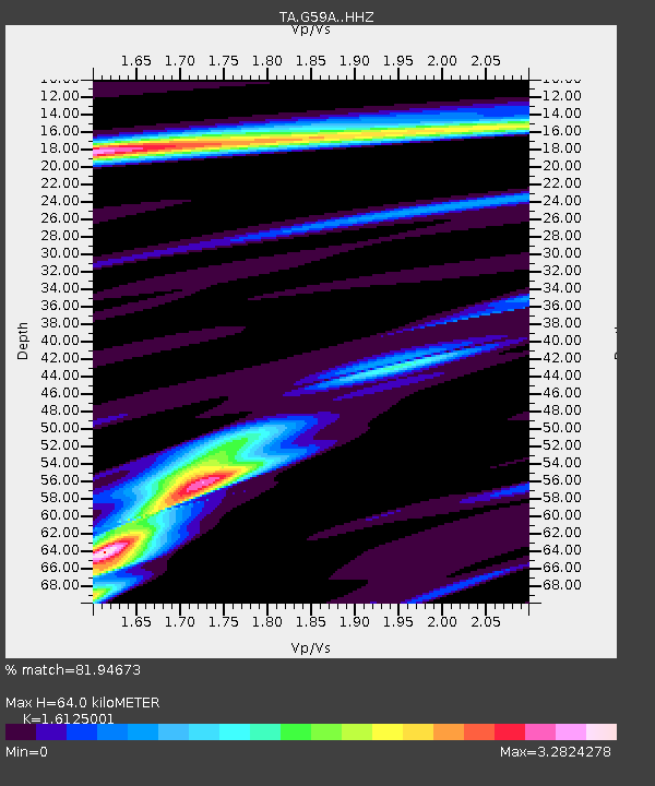
| Estimated Moho Depth: |
64.0 km |
| Estimated Crust Vp/Vs: |
1.61 |
| Assumed Crust Vp: |
6.419 km/s |
| Estimated Crust Vs: |
3.981 km/s |
| Estimated Crust Poisson's Ratio: |
0.19 |
|
| Radial Match: |
81.94673 % |
| Radial Bump: |
400 |
| Transverse Match: |
80.18805 % |
| Transverse Bump: |
400 |
| SOD ConfigId: |
7422571 |
| Insert Time: |
2019-04-17 18:59:00.216 +0000 |
| GWidth: |
2.5 |
| Max Bumps: |
400 |
| Tol: |
0.001 |
|
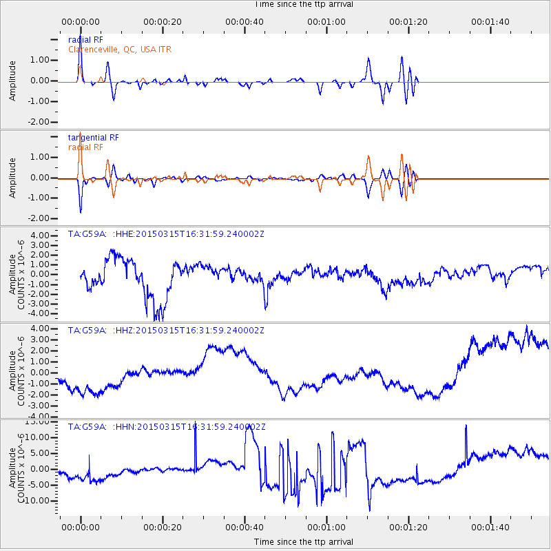
Signal To Noise
| Channel | StoN | STA | LTA |
| TA:G59A: :HHZ:20150315T16:31:59.240002Z | 1.4864725 | 3.8884837E-6 | 2.6159137E-6 |
| TA:G59A: :HHN:20150315T16:31:59.240002Z | 1.1305976 | 7.07315E-6 | 6.2561157E-6 |
| TA:G59A: :HHE:20150315T16:31:59.240002Z | 0.5749066 | 1.0918693E-6 | 1.8992117E-6 |
| Arrivals |
| Ps | 6.6 SECOND |
| PpPs | 24 SECOND |
| PsPs/PpSs | 31 SECOND |


