You are here: Home > Network List > TA - USArray Transportable Network (new EarthScope stations) Stations List
> Station G59A Clarenceville, QC, USA > Earthquake Result Viewer
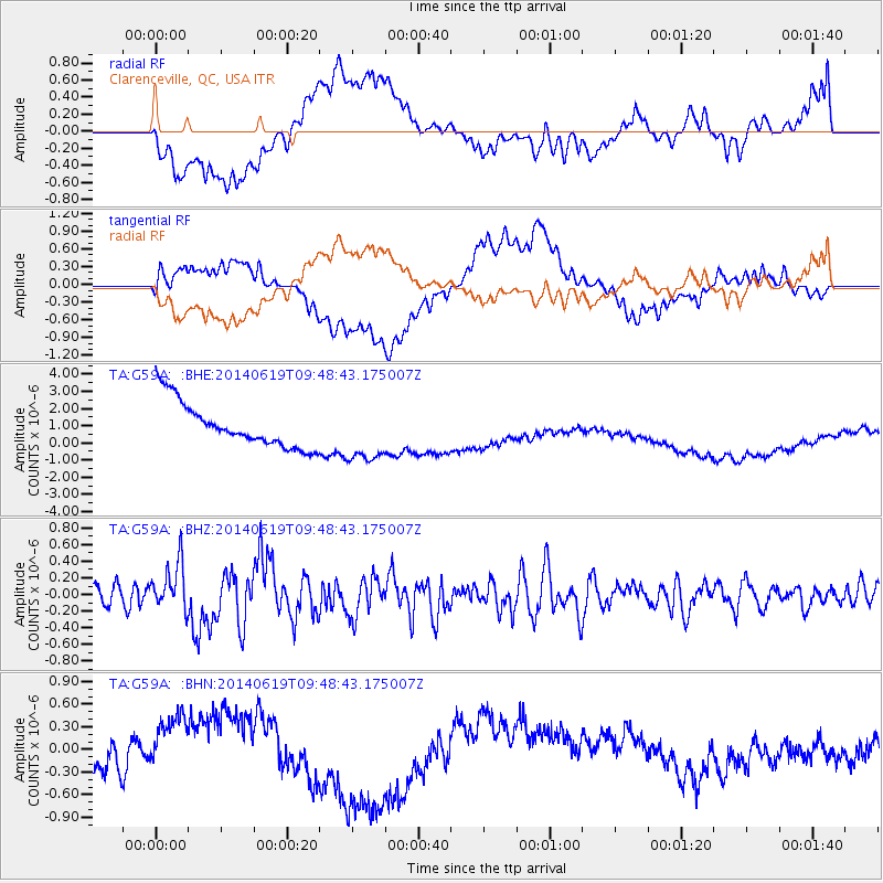
G59A Clarenceville, QC, USA - Earthquake Result Viewer
*The percent match for this event was below the threshold and hence no stack was calculated.
| Earthquake location: |
Near Coast Of Northern Chile |
| Earthquake latitude/longitude: |
-20.0/-70.9 |
| Earthquake time(UTC): |
2014/06/19 (170) 09:38:37 GMT |
| Earthquake Depth: |
19 km |
| Earthquake Magnitude: |
5.7 MWP |
| Earthquake Catalog/Contributor: |
NEIC PDE/NEIC COMCAT |
|
| Network: |
TA USArray Transportable Network (new EarthScope stations) |
| Station: |
G59A Clarenceville, QC, USA |
| Lat/Lon: |
45.08 N/73.18 W |
| Elevation: |
36 m |
|
| Distance: |
64.8 deg |
| Az: |
358.245 deg |
| Baz: |
177.669 deg |
| Ray Param: |
$rayparam |
*The percent match for this event was below the threshold and hence was not used in the summary stack. |
|
| Radial Match: |
42.808926 % |
| Radial Bump: |
400 |
| Transverse Match: |
17.552595 % |
| Transverse Bump: |
400 |
| SOD ConfigId: |
739768 |
| Insert Time: |
2014-07-03 10:10:23.200 +0000 |
| GWidth: |
2.5 |
| Max Bumps: |
400 |
| Tol: |
0.001 |
|
Signal To Noise
| Channel | StoN | STA | LTA |
| TA:G59A: :BHZ:20140619T09:48:43.175007Z | 2.4344678 | 2.845771E-7 | 1.16894995E-7 |
| TA:G59A: :BHN:20140619T09:48:43.175007Z | 0.87691784 | 2.397278E-7 | 2.7337543E-7 |
| TA:G59A: :BHE:20140619T09:48:43.175007Z | 1.3312058 | 1.7383418E-6 | 1.30584E-6 |
| Arrivals |
| Ps | |
| PpPs | |
| PsPs/PpSs | |


