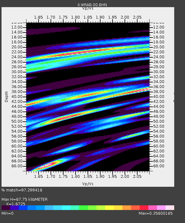
WRAB Tennant Creek, NT, Australia - Earthquake Result Viewer
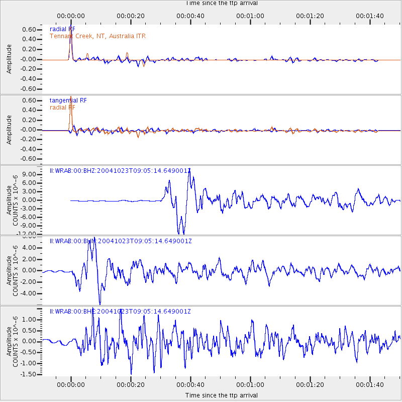
Earthquake location: Near West Coast Of Honshu, Japan
Earthquake latitude/longitude: 37.2/138.8
Earthquake time(UTC): 2004/10/23 (297) 08:56:00 GMT
Earthquake Depth: 16 km
Earthquake Magnitude: 6.4 MB, 6.3 MS, 6.6 MW, 6.4 MW
Earthquake Catalog/Contributor: WHDF/NEIC
Network: II Global Seismograph Network (GSN - IRIS/IDA)
Station: WRAB Tennant Creek, NT, Australia
Lat/Lon: 19.93 S/134.36 E
Elevation: 366 m
Distance: 57.0 deg
Az: 184.958 deg
Baz: 4.205 deg
Ray Param: 0.063756585
Estimated Moho Depth: 67.75 km
Estimated Crust Vp/Vs: 1.67
Assumed Crust Vp: 6.642 km/s
Estimated Crust Vs: 3.971 km/s
Estimated Crust Poisson's Ratio: 0.22
Radial Match: 97.299416 %
Radial Bump: 285
Transverse Match: 85.433105 %
Transverse Bump: 400
SOD ConfigId: 2459
Insert Time: 2010-03-01 23:09:36.696 +0000
GWidth: 2.5
Max Bumps: 400
Tol: 0.001

Signal To Noise

ChannelStoNSTALTA
II:WRAB:00:BHN:20041023T09:05:14.649001Z9.0196641.4574365E-61.6158435E-7
II:WRAB:00:BHE:20041023T09:05:14.649001Z1.69066272.4119694E-71.4266413E-7
II:WRAB:00:BHZ:20041023T09:05:14.649001Z25.3376312.9731918E-61.1734293E-7
Arrivals
Ps7.3 SECOND
PpPs26 SECOND
PsPs/PpSs33 SECOND