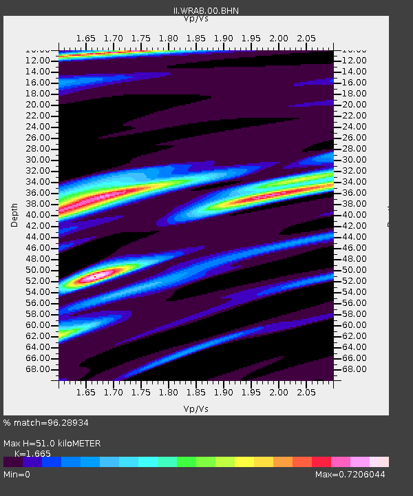
WRAB Tennant Creek, NT, Australia - Earthquake Result Viewer

Earthquake location: Off W. Coast Of S. Island, N.Z.
Earthquake latitude/longitude: -46.7/164.7
Earthquake time(UTC): 2004/11/22 (327) 20:26:23 GMT
Earthquake Depth: 10 km
Earthquake Magnitude: 6.4 MB, 7.1 MS, 7.1 MW, 7.0 MW
Earthquake Catalog/Contributor: WHDF/NEIC
Network: II Global Seismograph Network (GSN - IRIS/IDA)
Station: WRAB Tennant Creek, NT, Australia
Lat/Lon: 19.93 S/134.36 E
Elevation: 366 m
Distance: 36.4 deg
Az: 306.768 deg
Baz: 144.107 deg
Ray Param: 0.076693185
Estimated Moho Depth: 51.0 km
Estimated Crust Vp/Vs: 1.66
Assumed Crust Vp: 6.642 km/s
Estimated Crust Vs: 3.989 km/s
Estimated Crust Poisson's Ratio: 0.22
Radial Match: 96.28934 %
Radial Bump: 289
Transverse Match: 77.622185 %
Transverse Bump: 400
SOD ConfigId: 2459
Insert Time: 2010-03-01 23:09:55.561 +0000
GWidth: 2.5
Max Bumps: 400
Tol: 0.001

Signal To Noise

ChannelStoNSTALTA
II:WRAB:00:BHN:20041122T20:32:57.699011Z10.7014631.2132559E-61.1337291E-7
II:WRAB:00:BHE:20041122T20:32:57.699011Z5.8913398.7971665E-71.4932372E-7
II:WRAB:00:BHZ:20041122T20:32:57.699011Z9.7357092.4675476E-62.534533E-7
Arrivals
Ps5.6 SECOND
PpPs19 SECOND
PsPs/PpSs24 SECOND