You are here: Home > Network List > TA - USArray Transportable Network (new EarthScope stations) Stations List
> Station R58B Mineral, VA, USA > Earthquake Result Viewer
R58B Mineral, VA, USA - Earthquake Result Viewer
| Earthquake location: |
Near Coast Of Northern Chile |
| Earthquake latitude/longitude: |
-20.0/-70.9 |
| Earthquake time(UTC): |
2014/06/19 (170) 09:38:37 GMT |
| Earthquake Depth: |
19 km |
| Earthquake Magnitude: |
5.7 MWP |
| Earthquake Catalog/Contributor: |
NEIC PDE/NEIC COMCAT |
|
| Network: |
TA USArray Transportable Network (new EarthScope stations) |
| Station: |
R58B Mineral, VA, USA |
| Lat/Lon: |
37.96 N/77.88 W |
| Elevation: |
116 m |
|
| Distance: |
58.0 deg |
| Az: |
353.534 deg |
| Baz: |
172.298 deg |
| Ray Param: |
0.06311928 |
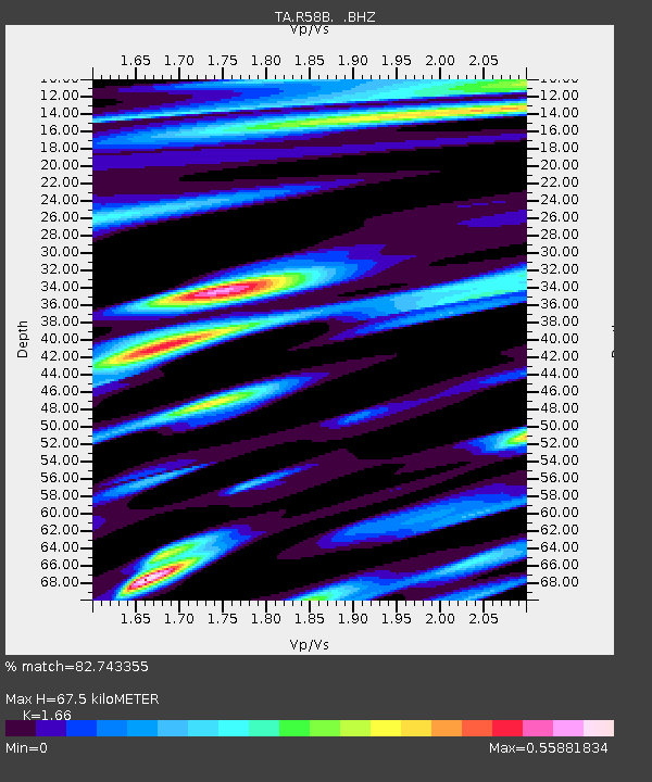
| Estimated Moho Depth: |
67.5 km |
| Estimated Crust Vp/Vs: |
1.66 |
| Assumed Crust Vp: |
6.565 km/s |
| Estimated Crust Vs: |
3.955 km/s |
| Estimated Crust Poisson's Ratio: |
0.22 |
|
| Radial Match: |
82.743355 % |
| Radial Bump: |
400 |
| Transverse Match: |
51.939438 % |
| Transverse Bump: |
400 |
| SOD ConfigId: |
739768 |
| Insert Time: |
2014-07-03 10:18:30.174 +0000 |
| GWidth: |
2.5 |
| Max Bumps: |
400 |
| Tol: |
0.001 |
|

Signal To Noise
| Channel | StoN | STA | LTA |
| TA:R58B: :BHZ:20140619T09:47:57.425007Z | 5.937197 | 3.2672054E-7 | 5.502942E-8 |
| TA:R58B: :BHN:20140619T09:47:57.425007Z | 3.1962285 | 1.7060927E-7 | 5.3378308E-8 |
| TA:R58B: :BHE:20140619T09:47:57.425007Z | 1.3894346 | 8.115907E-8 | 5.8411583E-8 |
| Arrivals |
| Ps | 7.2 SECOND |
| PpPs | 26 SECOND |
| PsPs/PpSs | 33 SECOND |


