You are here: Home > Network List > TA - USArray Transportable Network (new EarthScope stations) Stations List
> Station 121A Cookes Peak, Deming, NM, USA > Earthquake Result Viewer
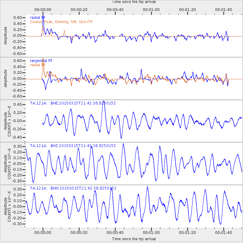
121A Cookes Peak, Deming, NM, USA - Earthquake Result Viewer
*The percent match for this event was below the threshold and hence no stack was calculated.
| Earthquake location: |
Vanuatu Islands |
| Earthquake latitude/longitude: |
-15.2/166.8 |
| Earthquake time(UTC): |
2015/03/15 (074) 21:29:57 GMT |
| Earthquake Depth: |
57 km |
| Earthquake Magnitude: |
5.4 MW |
| Earthquake Catalog/Contributor: |
ISC/ISC |
|
| Network: |
TA USArray Transportable Network (new EarthScope stations) |
| Station: |
121A Cookes Peak, Deming, NM, USA |
| Lat/Lon: |
32.53 N/107.79 W |
| Elevation: |
1652 m |
|
| Distance: |
94.2 deg |
| Az: |
57.594 deg |
| Baz: |
254.78 deg |
| Ray Param: |
$rayparam |
*The percent match for this event was below the threshold and hence was not used in the summary stack. |
|
| Radial Match: |
63.481625 % |
| Radial Bump: |
400 |
| Transverse Match: |
40.800133 % |
| Transverse Bump: |
400 |
| SOD ConfigId: |
7422571 |
| Insert Time: |
2019-04-17 19:03:12.863 +0000 |
| GWidth: |
2.5 |
| Max Bumps: |
400 |
| Tol: |
0.001 |
|
Signal To Noise
| Channel | StoN | STA | LTA |
| TA:121A: :BHZ:20150315T21:42:38.825015Z | 0.60691756 | 1.3259142E-7 | 2.1846695E-7 |
| TA:121A: :BHN:20150315T21:42:38.825015Z | 0.47543782 | 1.05334095E-7 | 2.2155179E-7 |
| TA:121A: :BHE:20150315T21:42:38.825015Z | 1.824498 | 2.5137896E-7 | 1.377798E-7 |
| Arrivals |
| Ps | |
| PpPs | |
| PsPs/PpSs | |


