You are here: Home > Network List > TA - USArray Transportable Network (new EarthScope stations) Stations List
> Station W58A Raeford, NC, USA > Earthquake Result Viewer
W58A Raeford, NC, USA - Earthquake Result Viewer
| Earthquake location: |
Near Coast Of Northern Chile |
| Earthquake latitude/longitude: |
-20.0/-70.9 |
| Earthquake time(UTC): |
2014/06/19 (170) 09:38:37 GMT |
| Earthquake Depth: |
19 km |
| Earthquake Magnitude: |
5.7 MWP |
| Earthquake Catalog/Contributor: |
NEIC PDE/NEIC COMCAT |
|
| Network: |
TA USArray Transportable Network (new EarthScope stations) |
| Station: |
W58A Raeford, NC, USA |
| Lat/Lon: |
35.02 N/79.23 W |
| Elevation: |
84 m |
|
| Distance: |
55.2 deg |
| Az: |
351.715 deg |
| Baz: |
170.494 deg |
| Ray Param: |
0.06489903 |
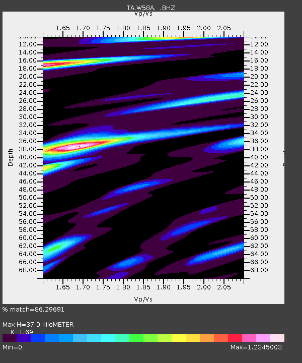
| Estimated Moho Depth: |
37.0 km |
| Estimated Crust Vp/Vs: |
1.69 |
| Assumed Crust Vp: |
6.565 km/s |
| Estimated Crust Vs: |
3.884 km/s |
| Estimated Crust Poisson's Ratio: |
0.23 |
|
| Radial Match: |
86.29691 % |
| Radial Bump: |
400 |
| Transverse Match: |
62.935482 % |
| Transverse Bump: |
400 |
| SOD ConfigId: |
739768 |
| Insert Time: |
2014-07-03 10:21:10.623 +0000 |
| GWidth: |
2.5 |
| Max Bumps: |
400 |
| Tol: |
0.001 |
|
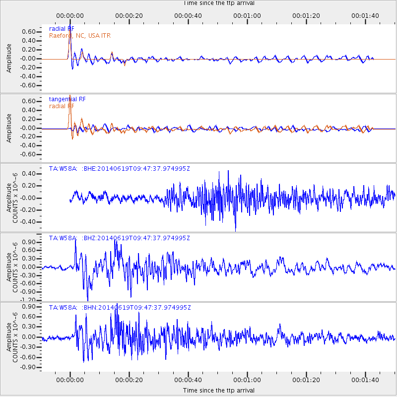
Signal To Noise
| Channel | StoN | STA | LTA |
| TA:W58A: :BHZ:20140619T09:47:37.974995Z | 5.774425 | 3.4270568E-7 | 5.9348878E-8 |
| TA:W58A: :BHN:20140619T09:47:37.974995Z | 6.1116786 | 2.7783983E-7 | 4.5460478E-8 |
| TA:W58A: :BHE:20140619T09:47:37.974995Z | 1.7280852 | 8.175626E-8 | 4.731032E-8 |
| Arrivals |
| Ps | 4.1 SECOND |
| PpPs | 14 SECOND |
| PsPs/PpSs | 18 SECOND |


