You are here: Home > Network List > TA - USArray Transportable Network (new EarthScope stations) Stations List
> Station W59A Clinton, NC, USA > Earthquake Result Viewer
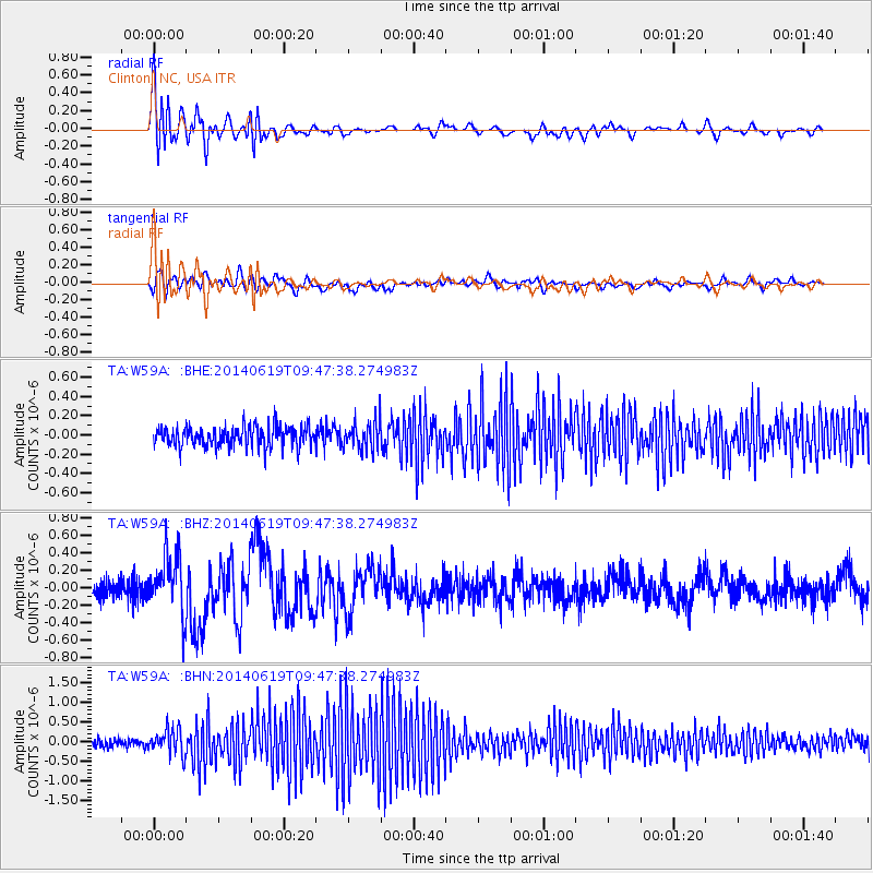
W59A Clinton, NC, USA - Earthquake Result Viewer
*The percent match for this event was below the threshold and hence no stack was calculated.
| Earthquake location: |
Near Coast Of Northern Chile |
| Earthquake latitude/longitude: |
-20.0/-70.9 |
| Earthquake time(UTC): |
2014/06/19 (170) 09:38:37 GMT |
| Earthquake Depth: |
19 km |
| Earthquake Magnitude: |
5.7 MWP |
| Earthquake Catalog/Contributor: |
NEIC PDE/NEIC COMCAT |
|
| Network: |
TA USArray Transportable Network (new EarthScope stations) |
| Station: |
W59A Clinton, NC, USA |
| Lat/Lon: |
35.17 N/78.44 W |
| Elevation: |
60 m |
|
| Distance: |
55.3 deg |
| Az: |
352.522 deg |
| Baz: |
171.406 deg |
| Ray Param: |
$rayparam |
*The percent match for this event was below the threshold and hence was not used in the summary stack. |
|
| Radial Match: |
69.15281 % |
| Radial Bump: |
400 |
| Transverse Match: |
58.078346 % |
| Transverse Bump: |
400 |
| SOD ConfigId: |
739768 |
| Insert Time: |
2014-07-03 10:21:14.729 +0000 |
| GWidth: |
2.5 |
| Max Bumps: |
400 |
| Tol: |
0.001 |
|
Signal To Noise
| Channel | StoN | STA | LTA |
| TA:W59A: :BHZ:20140619T09:47:38.274983Z | 2.975499 | 3.2876505E-7 | 1.1049074E-7 |
| TA:W59A: :BHN:20140619T09:47:38.274983Z | 3.1601887 | 3.204777E-7 | 1.0141094E-7 |
| TA:W59A: :BHE:20140619T09:47:38.274983Z | 1.3858317 | 1.4472111E-7 | 1.0442906E-7 |
| Arrivals |
| Ps | |
| PpPs | |
| PsPs/PpSs | |


