You are here: Home > Network List > US - United States National Seismic Network Stations List
> Station HAWA Hanford, Washington, USA > Earthquake Result Viewer
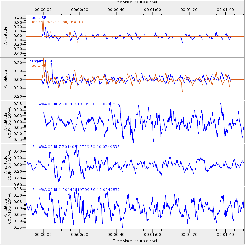
HAWA Hanford, Washington, USA - Earthquake Result Viewer
*The percent match for this event was below the threshold and hence no stack was calculated.
| Earthquake location: |
Near Coast Of Northern Chile |
| Earthquake latitude/longitude: |
-20.0/-70.9 |
| Earthquake time(UTC): |
2014/06/19 (170) 09:38:37 GMT |
| Earthquake Depth: |
19 km |
| Earthquake Magnitude: |
5.7 MWP |
| Earthquake Catalog/Contributor: |
NEIC PDE/NEIC COMCAT |
|
| Network: |
US United States National Seismic Network |
| Station: |
HAWA Hanford, Washington, USA |
| Lat/Lon: |
46.39 N/119.53 W |
| Elevation: |
364 m |
|
| Distance: |
79.3 deg |
| Az: |
328.109 deg |
| Baz: |
134.11 deg |
| Ray Param: |
$rayparam |
*The percent match for this event was below the threshold and hence was not used in the summary stack. |
|
| Radial Match: |
64.167595 % |
| Radial Bump: |
400 |
| Transverse Match: |
62.749886 % |
| Transverse Bump: |
400 |
| SOD ConfigId: |
739768 |
| Insert Time: |
2014-07-03 10:23:33.041 +0000 |
| GWidth: |
2.5 |
| Max Bumps: |
400 |
| Tol: |
0.001 |
|
Signal To Noise
| Channel | StoN | STA | LTA |
| US:HAWA:00:BHZ:20140619T09:50:10.024983Z | 2.641857 | 1.6735724E-7 | 6.334834E-8 |
| US:HAWA:00:BH1:20140619T09:50:10.024983Z | 1.4172338 | 5.997211E-8 | 4.2316316E-8 |
| US:HAWA:00:BH2:20140619T09:50:10.024983Z | 1.408882 | 5.2881326E-8 | 3.7534246E-8 |
| Arrivals |
| Ps | |
| PpPs | |
| PsPs/PpSs | |


