You are here: Home > Network List > II - Global Seismograph Network (GSN - IRIS/IDA) Stations List
> Station WRAB Tennant Creek, NT, Australia > Earthquake Result Viewer
WRAB Tennant Creek, NT, Australia - Earthquake Result Viewer
| Earthquake location: |
Southeast Of Taiwan |
| Earthquake latitude/longitude: |
22.3/125.3 |
| Earthquake time(UTC): |
1998/05/03 (123) 23:30:21 GMT |
| Earthquake Depth: |
33 km |
| Earthquake Magnitude: |
6.4 MB, 7.3 MS, 7.5 UNKNOWN, 7.5 ME |
| Earthquake Catalog/Contributor: |
WHDF/NEIC |
|
| Network: |
II Global Seismograph Network (GSN - IRIS/IDA) |
| Station: |
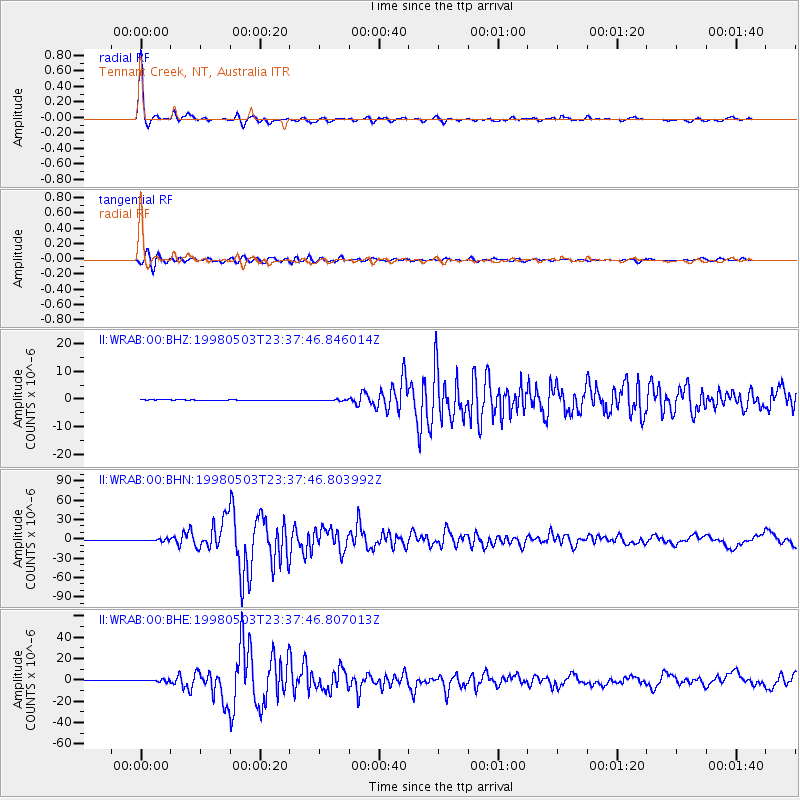
WRAB Tennant Creek, NT, Australia |
| Lat/Lon: |
19.93 S/134.36 E |
| Elevation: |
366 m |
|
| Distance: |
42.9 deg |
| Az: |
167.442 deg |
| Baz: |
347.642 deg |
| Ray Param: |
0.07282709 |
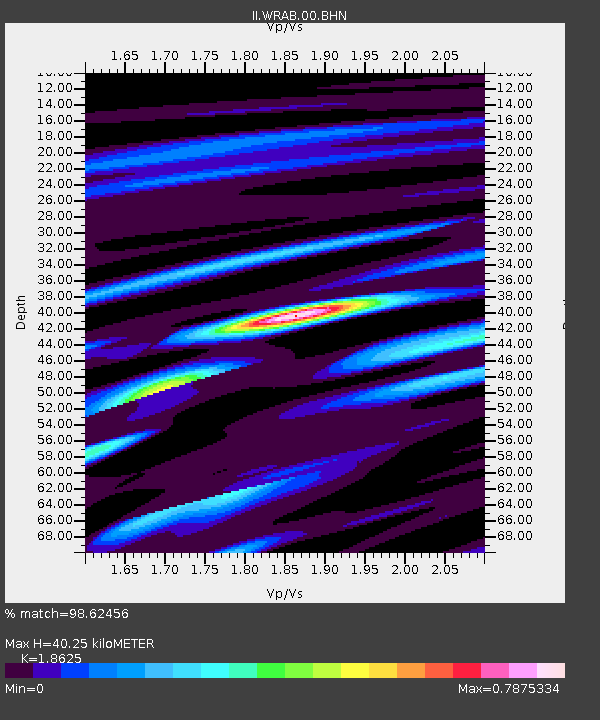
| Estimated Moho Depth: |
40.25 km |
| Estimated Crust Vp/Vs: |
1.86 |
| Assumed Crust Vp: |
6.642 km/s |
| Estimated Crust Vs: |
3.566 km/s |
| Estimated Crust Poisson's Ratio: |
0.30 |
|
| Radial Match: |
98.62456 % |
| Radial Bump: |
282 |
| Transverse Match: |
93.726746 % |
| Transverse Bump: |
400 |
| SOD ConfigId: |
4480 |
| Insert Time: |
2010-03-01 23:10:22.978 +0000 |
| GWidth: |
2.5 |
| Max Bumps: |
400 |
| Tol: |
0.001 |
|
Signal To Noise
| Channel | StoN | STA | LTA |
| II:WRAB:00:BHN:19980503T23:37:46.803992Z | 3.8003867 | 1.5153493E-6 | 3.9873555E-7 |
| II:WRAB:00:BHE:19980503T23:37:46.807013Z | 3.5573509 | 1.0704047E-6 | 3.008994E-7 |
| II:WRAB:00:BHZ:19980503T23:37:46.846014Z | 2.638202 | 2.4618927E-7 | 9.331707E-8 |
| Arrivals |
| Ps | 5.6 SECOND |
| PpPs | 16 SECOND |
| PsPs/PpSs | 22 SECOND |


