You are here: Home > Network List > II - Global Seismograph Network (GSN - IRIS/IDA) Stations List
> Station WRAB Tennant Creek, NT, Australia > Earthquake Result Viewer
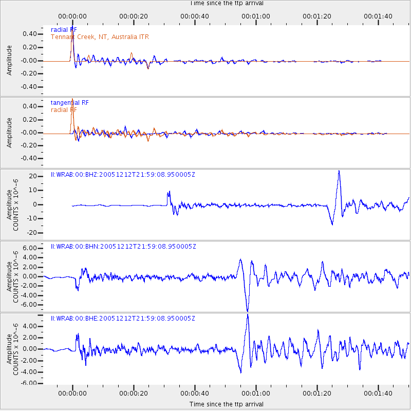
WRAB Tennant Creek, NT, Australia - Earthquake Result Viewer
| Earthquake location: |
Afghanistan-Tajikistan Bord Reg. |
| Earthquake latitude/longitude: |
36.4/71.1 |
| Earthquake time(UTC): |
2005/12/12 (346) 21:47:46 GMT |
| Earthquake Depth: |
225 km |
| Earthquake Magnitude: |
6.0 MB, 6.5 MW, 6.5 MW |
| Earthquake Catalog/Contributor: |
WHDF/NEIC |
|
| Network: |
II Global Seismograph Network (GSN - IRIS/IDA) |
| Station: |
WRAB Tennant Creek, NT, Australia |
| Lat/Lon: |
19.93 S/134.36 E |
| Elevation: |
366 m |
|
| Distance: |
81.9 deg |
| Az: |
121.918 deg |
| Baz: |
313.257 deg |
| Ray Param: |
0.046732165 |
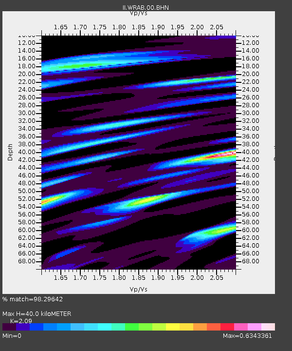
| Estimated Moho Depth: |
40.0 km |
| Estimated Crust Vp/Vs: |
2.09 |
| Assumed Crust Vp: |
6.642 km/s |
| Estimated Crust Vs: |
3.178 km/s |
| Estimated Crust Poisson's Ratio: |
0.35 |
|
| Radial Match: |
98.29642 % |
| Radial Bump: |
338 |
| Transverse Match: |
93.12741 % |
| Transverse Bump: |
400 |
| SOD ConfigId: |
2422 |
| Insert Time: |
2010-03-01 23:10:44.293 +0000 |
| GWidth: |
2.5 |
| Max Bumps: |
400 |
| Tol: |
0.001 |
|
Signal To Noise
| Channel | StoN | STA | LTA |
| II:WRAB:00:BHN:20051212T21:59:08.950005Z | 11.772946 | 1.2514403E-6 | 1.0629797E-7 |
| II:WRAB:00:BHE:20051212T21:59:08.950005Z | 8.170862 | 1.1582771E-6 | 1.4175703E-7 |
| II:WRAB:00:BHZ:20051212T21:59:08.950005Z | 16.754858 | 4.1186827E-6 | 2.458202E-7 |
| Arrivals |
| Ps | 6.7 SECOND |
| PpPs | 18 SECOND |
| PsPs/PpSs | 25 SECOND |


