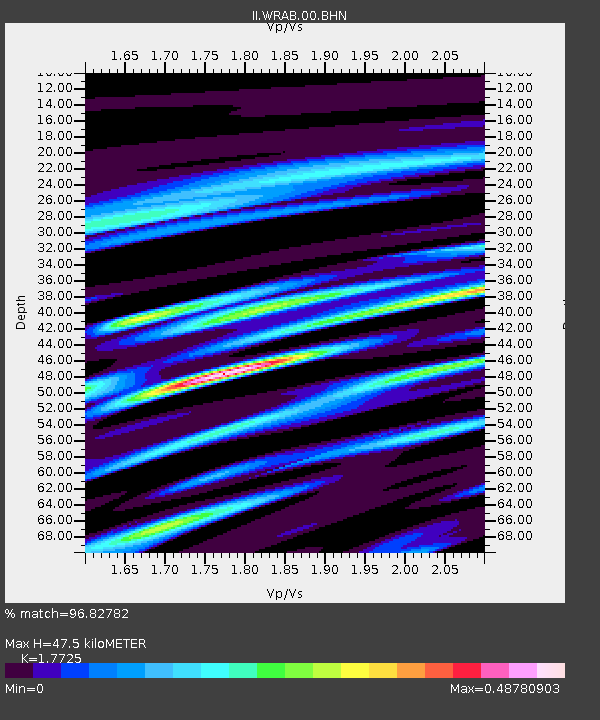
WRAB Tennant Creek, NT, Australia - Earthquake Result Viewer

Earthquake location: Near East Coast Of Honshu, Japan
Earthquake latitude/longitude: 38.1/142.1
Earthquake time(UTC): 2005/12/02 (336) 13:13:09 GMT
Earthquake Depth: 29 km
Earthquake Magnitude: 6.1 MB, 6.3 MS, 6.5 MW, 6.4 MW
Earthquake Catalog/Contributor: WHDF/NEIC
Network: II Global Seismograph Network (GSN - IRIS/IDA)
Station: WRAB Tennant Creek, NT, Australia
Lat/Lon: 19.93 S/134.36 E
Elevation: 366 m
Distance: 58.2 deg
Az: 188.601 deg
Baz: 7.205 deg
Ray Param: 0.06297041
Estimated Moho Depth: 47.5 km
Estimated Crust Vp/Vs: 1.77
Assumed Crust Vp: 6.642 km/s
Estimated Crust Vs: 3.747 km/s
Estimated Crust Poisson's Ratio: 0.27
Radial Match: 96.82782 %
Radial Bump: 238
Transverse Match: 85.22267 %
Transverse Bump: 400
SOD ConfigId: 2422
Insert Time: 2010-03-01 23:10:51.307 +0000
GWidth: 2.5
Max Bumps: 400
Tol: 0.001

Signal To Noise

ChannelStoNSTALTA
II:WRAB:00:BHN:20051202T13:22:29.900005Z7.74220136.692363E-78.644005E-8
II:WRAB:00:BHE:20051202T13:22:29.900005Z4.1538222.3011334E-75.539798E-8
II:WRAB:00:BHZ:20051202T13:22:29.900005Z13.4307281.4949843E-61.1131075E-7
Arrivals
Ps5.8 SECOND
PpPs19 SECOND
PsPs/PpSs25 SECOND