You are here: Home > Network List > IU - Global Seismograph Network (GSN - IRIS/USGS) Stations List
> Station KBL Kabul, Afghanistan > Earthquake Result Viewer
KBL Kabul, Afghanistan - Earthquake Result Viewer
| Earthquake location: |
Minahassa Peninsula, Sulawesi |
| Earthquake latitude/longitude: |
-0.5/122.3 |
| Earthquake time(UTC): |
2015/03/15 (074) 23:17:18 GMT |
| Earthquake Depth: |
44 km |
| Earthquake Magnitude: |
5.9 MO |
| Earthquake Catalog/Contributor: |
NEIC PDE/NEIC ALERT |
|
| Network: |
IU Global Seismograph Network (GSN - IRIS/USGS) |
| Station: |
KBL Kabul, Afghanistan |
| Lat/Lon: |
34.54 N/69.04 E |
| Elevation: |
1920 m |
|
| Distance: |
60.8 deg |
| Az: |
310.685 deg |
| Baz: |
113.282 deg |
| Ray Param: |
0.061231274 |
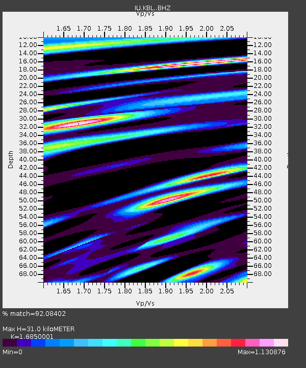
| Estimated Moho Depth: |
31.0 km |
| Estimated Crust Vp/Vs: |
1.69 |
| Assumed Crust Vp: |
6.641 km/s |
| Estimated Crust Vs: |
3.941 km/s |
| Estimated Crust Poisson's Ratio: |
0.23 |
|
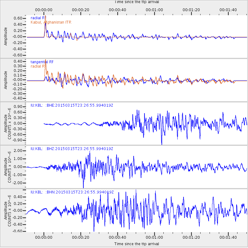
| Radial Match: |
92.08402 % |
| Radial Bump: |
400 |
| Transverse Match: |
85.9002 % |
| Transverse Bump: |
400 |
| SOD ConfigId: |
7422571 |
| Insert Time: |
2019-04-17 19:11:00.477 +0000 |
| GWidth: |
2.5 |
| Max Bumps: |
400 |
| Tol: |
0.001 |
|
Signal To Noise
| Channel | StoN | STA | LTA |
| IU:KBL: :BHZ:20150315T23:26:55.994019Z | 2.3611455 | 1.2671505E-7 | 5.3666774E-8 |
| IU:KBL: :BHN:20150315T23:26:55.994019Z | 1.21435 | 6.3296284E-8 | 5.212359E-8 |
| IU:KBL: :BHE:20150315T23:26:55.994019Z | 1.445968 | 5.151866E-8 | 3.5629185E-8 |
| Arrivals |
| Ps | 3.4 SECOND |
| PpPs | 12 SECOND |
| PsPs/PpSs | 15 SECOND |


