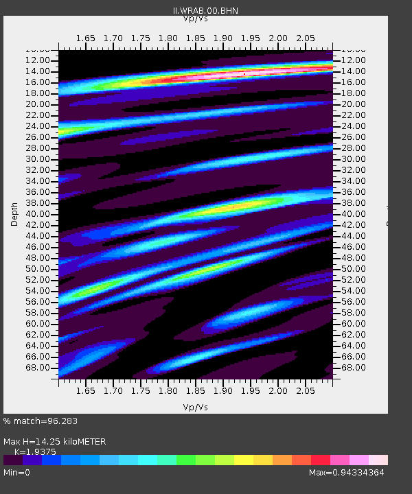
WRAB Tennant Creek, NT, Australia - Earthquake Result Viewer
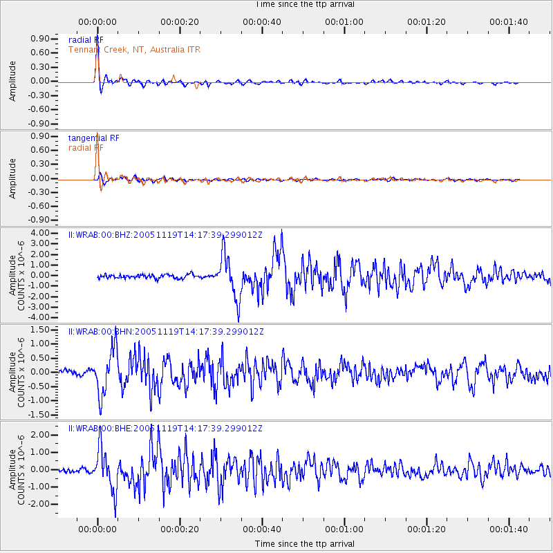
Earthquake location: Northern Sumatra, Indonesia
Earthquake latitude/longitude: 2.2/96.8
Earthquake time(UTC): 2005/11/19 (323) 14:10:13 GMT
Earthquake Depth: 21 km
Earthquake Magnitude: 6.0 MB, 6.1 MS, 6.5 MW, 6.5 MW
Earthquake Catalog/Contributor: WHDF/NEIC
Network: II Global Seismograph Network (GSN - IRIS/IDA)
Station: WRAB Tennant Creek, NT, Australia
Lat/Lon: 19.93 S/134.36 E
Elevation: 366 m
Distance: 42.9 deg
Az: 122.582 deg
Baz: 296.492 deg
Ray Param: 0.07285941
Estimated Moho Depth: 14.25 km
Estimated Crust Vp/Vs: 1.94
Assumed Crust Vp: 6.642 km/s
Estimated Crust Vs: 3.428 km/s
Estimated Crust Poisson's Ratio: 0.32
Radial Match: 96.283 %
Radial Bump: 309
Transverse Match: 75.254616 %
Transverse Bump: 400
SOD ConfigId: 2448
Insert Time: 2010-03-01 23:11:08.326 +0000
GWidth: 2.5
Max Bumps: 400
Tol: 0.001

Signal To Noise

ChannelStoNSTALTA
II:WRAB:00:BHN:20051119T14:17:39.299012Z6.3446528.2709363E-71.3036076E-7
II:WRAB:00:BHE:20051119T14:17:39.299012Z12.9109971.2420634E-69.620197E-8
II:WRAB:00:BHZ:20051119T14:17:39.299012Z12.2047642.1364763E-61.7505265E-7
Arrivals
Ps2.1 SECOND
PpPs5.9 SECOND
PsPs/PpSs8.1 SECOND