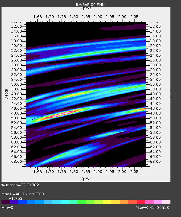
WRAB Tennant Creek, NT, Australia - Earthquake Result Viewer

Earthquake location: Off East Coast Of Honshu, Japan
Earthquake latitude/longitude: 38.1/144.9
Earthquake time(UTC): 2005/11/14 (318) 21:38:51 GMT
Earthquake Depth: 11 km
Earthquake Magnitude: 6.7 MB, 6.8 MS, 7.0 MW, 6.9 MW
Earthquake Catalog/Contributor: WHDF/NEIC
Network: II Global Seismograph Network (GSN - IRIS/IDA)
Station: WRAB Tennant Creek, NT, Australia
Lat/Lon: 19.93 S/134.36 E
Elevation: 366 m
Distance: 58.6 deg
Az: 191.631 deg
Baz: 9.732 deg
Ray Param: 0.06275294
Estimated Moho Depth: 48.0 km
Estimated Crust Vp/Vs: 1.75
Assumed Crust Vp: 6.642 km/s
Estimated Crust Vs: 3.785 km/s
Estimated Crust Poisson's Ratio: 0.26
Radial Match: 97.31382 %
Radial Bump: 350
Transverse Match: 88.29322 %
Transverse Bump: 400
SOD ConfigId: 2448
Insert Time: 2010-03-01 23:11:12.008 +0000
GWidth: 2.5
Max Bumps: 400
Tol: 0.001

Signal To Noise

ChannelStoNSTALTA
II:WRAB:00:BHN:20051114T21:48:17.000017Z10.3244331.7144059E-61.6605327E-7
II:WRAB:00:BHE:20051114T21:48:17.000017Z1.91131352.9260625E-71.530917E-7
II:WRAB:00:BHZ:20051114T21:48:17.000017Z16.213123.4853717E-62.149723E-7
Arrivals
Ps5.8 SECOND
PpPs19 SECOND
PsPs/PpSs25 SECOND