You are here: Home > Network List > TA - USArray Transportable Network (new EarthScope stations) Stations List
> Station J01E Myrtle Point, OR, USA > Earthquake Result Viewer
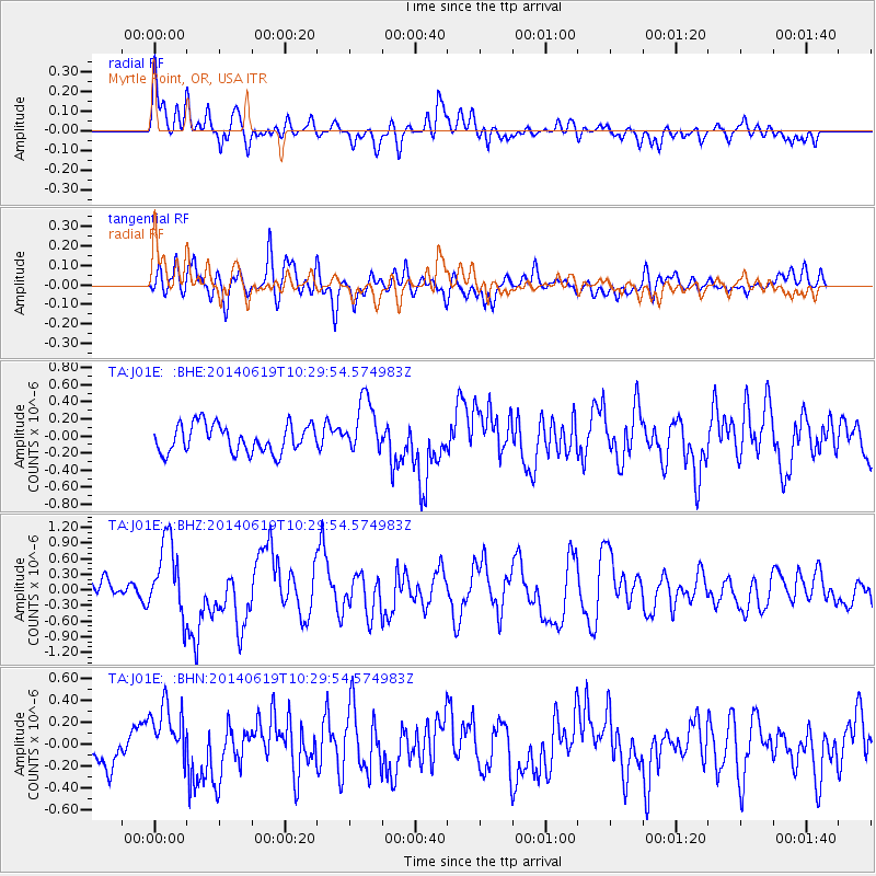
J01E Myrtle Point, OR, USA - Earthquake Result Viewer
*The percent match for this event was below the threshold and hence no stack was calculated.
| Earthquake location: |
Vanuatu Islands |
| Earthquake latitude/longitude: |
-13.6/166.8 |
| Earthquake time(UTC): |
2014/06/19 (170) 10:17:58 GMT |
| Earthquake Depth: |
60 km |
| Earthquake Magnitude: |
6.4 MWP |
| Earthquake Catalog/Contributor: |
NEIC PDE/NEIC COMCAT |
|
| Network: |
TA USArray Transportable Network (new EarthScope stations) |
| Station: |
J01E Myrtle Point, OR, USA |
| Lat/Lon: |
43.16 N/123.93 W |
| Elevation: |
128 m |
|
| Distance: |
84.7 deg |
| Az: |
43.41 deg |
| Baz: |
245.961 deg |
| Ray Param: |
$rayparam |
*The percent match for this event was below the threshold and hence was not used in the summary stack. |
|
| Radial Match: |
66.893135 % |
| Radial Bump: |
400 |
| Transverse Match: |
69.90785 % |
| Transverse Bump: |
400 |
| SOD ConfigId: |
739768 |
| Insert Time: |
2014-07-03 10:52:19.926 +0000 |
| GWidth: |
2.5 |
| Max Bumps: |
400 |
| Tol: |
0.001 |
|
Signal To Noise
| Channel | StoN | STA | LTA |
| TA:J01E: :BHZ:20140619T10:29:54.574983Z | 3.3733275 | 7.211759E-7 | 2.137877E-7 |
| TA:J01E: :BHN:20140619T10:29:54.574983Z | 2.4115212 | 2.89826E-7 | 1.201839E-7 |
| TA:J01E: :BHE:20140619T10:29:54.574983Z | 1.9837334 | 3.2339148E-7 | 1.6302164E-7 |
| Arrivals |
| Ps | |
| PpPs | |
| PsPs/PpSs | |


