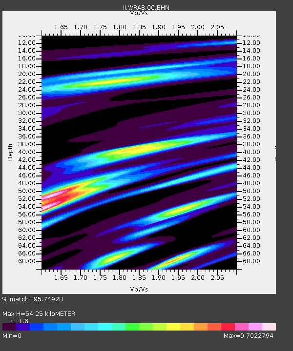
WRAB Tennant Creek, NT, Australia - Earthquake Result Viewer
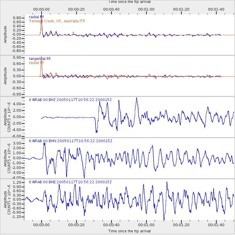
Earthquake location: W. Caroline Islands, Micronesia
Earthquake latitude/longitude: 11.0/140.7
Earthquake time(UTC): 2005/01/17 (017) 10:50:32 GMT
Earthquake Depth: 12 km
Earthquake Magnitude: 5.9 MB, 5.9 MS, 6.1 MW, 6.1 MW
Earthquake Catalog/Contributor: WHDF/NEIC
Network: II Global Seismograph Network (GSN - IRIS/IDA)
Station: WRAB Tennant Creek, NT, Australia
Lat/Lon: 19.93 S/134.36 E
Elevation: 366 m
Distance: 31.3 deg
Az: 191.486 deg
Baz: 11.995 deg
Ray Param: 0.07909026
Estimated Moho Depth: 54.25 km
Estimated Crust Vp/Vs: 1.60
Assumed Crust Vp: 6.642 km/s
Estimated Crust Vs: 4.151 km/s
Estimated Crust Poisson's Ratio: 0.18
Radial Match: 95.74928 %
Radial Bump: 279
Transverse Match: 72.75449 %
Transverse Bump: 400
SOD ConfigId: 5233
Insert Time: 2010-03-01 23:11:32.680 +0000
GWidth: 2.5
Max Bumps: 400
Tol: 0.001

Signal To Noise

ChannelStoNSTALTA
II:WRAB:00:BHN:20050117T10:56:22.200015Z17.1079391.7553823E-61.026063E-7
II:WRAB:00:BHE:20050117T10:56:22.200015Z3.24940853.6623706E-71.1270884E-7
II:WRAB:00:BHZ:20050117T10:56:22.200015Z27.903222.723096E-69.759076E-8
Arrivals
Ps5.4 SECOND
PpPs19 SECOND
PsPs/PpSs25 SECOND