You are here: Home > Network List > UW - Pacific Northwest Regional Seismic Network Stations List
> Station HOOD Mt Hood Meadows, OR CREST BB SMO > Earthquake Result Viewer
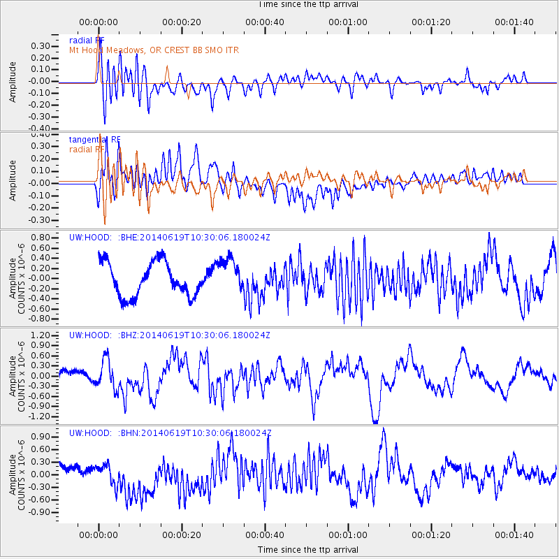
HOOD Mt Hood Meadows, OR CREST BB SMO - Earthquake Result Viewer
*The percent match for this event was below the threshold and hence no stack was calculated.
| Earthquake location: |
Vanuatu Islands |
| Earthquake latitude/longitude: |
-13.6/166.8 |
| Earthquake time(UTC): |
2014/06/19 (170) 10:17:58 GMT |
| Earthquake Depth: |
60 km |
| Earthquake Magnitude: |
6.4 MWP |
| Earthquake Catalog/Contributor: |
NEIC PDE/NEIC COMCAT |
|
| Network: |
UW Pacific Northwest Regional Seismic Network |
| Station: |
HOOD Mt Hood Meadows, OR CREST BB SMO |
| Lat/Lon: |
45.32 N/121.65 W |
| Elevation: |
1520 m |
|
| Distance: |
87.0 deg |
| Az: |
42.071 deg |
| Baz: |
247.448 deg |
| Ray Param: |
$rayparam |
*The percent match for this event was below the threshold and hence was not used in the summary stack. |
|
| Radial Match: |
59.47561 % |
| Radial Bump: |
400 |
| Transverse Match: |
71.53509 % |
| Transverse Bump: |
400 |
| SOD ConfigId: |
739768 |
| Insert Time: |
2014-07-03 10:56:29.092 +0000 |
| GWidth: |
2.5 |
| Max Bumps: |
400 |
| Tol: |
0.001 |
|
Signal To Noise
| Channel | StoN | STA | LTA |
| UW:HOOD: :BHZ:20140619T10:30:06.180024Z | 2.2401233 | 4.4543052E-7 | 1.9884196E-7 |
| UW:HOOD: :BHN:20140619T10:30:06.180024Z | 2.3175685 | 2.6147356E-7 | 1.1282236E-7 |
| UW:HOOD: :BHE:20140619T10:30:06.180024Z | 1.029132 | 3.446231E-7 | 3.3486774E-7 |
| Arrivals |
| Ps | |
| PpPs | |
| PsPs/PpSs | |


