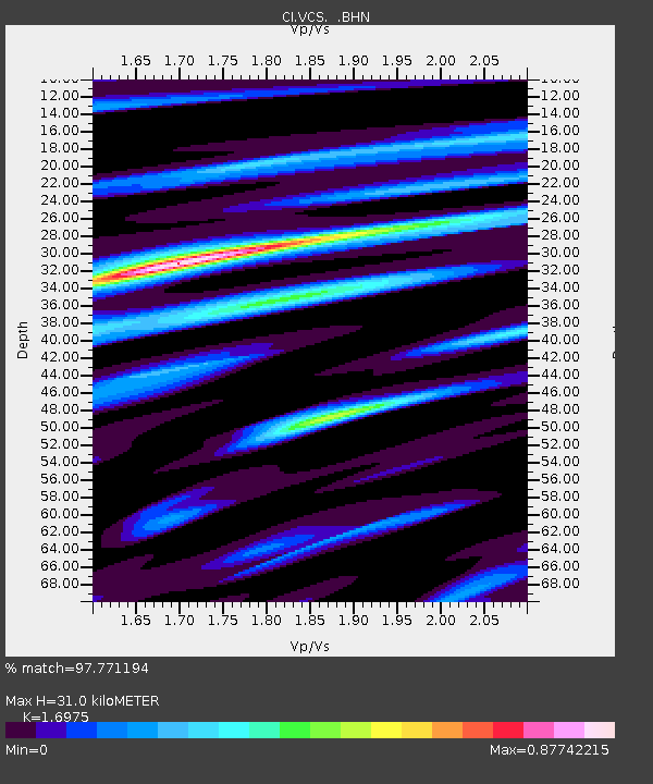
VCS Vincent SCE, California, USA - Earthquake Result Viewer
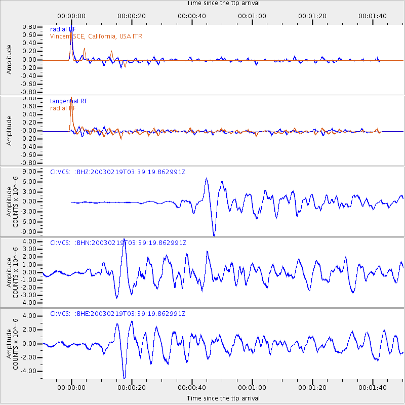
Earthquake location: Unimak Island Region, Alaska
Earthquake latitude/longitude: 53.6/-164.6
Earthquake time(UTC): 2003/02/19 (050) 03:32:36 GMT
Earthquake Depth: 19 km
Earthquake Magnitude: 5.8 MB, 6.6 MS, 6.6 MW, 6.6 MW
Earthquake Catalog/Contributor: WHDF/NEIC
Network: CI Caltech Regional Seismic Network
Station: VCS Vincent SCE, California, USA
Lat/Lon: 34.48 N/118.11 W
Elevation: 962 m
Distance: 37.7 deg
Az: 101.415 deg
Baz: 315.051 deg
Ray Param: 0.0759629
Estimated Moho Depth: 31.0 km
Estimated Crust Vp/Vs: 1.70
Assumed Crust Vp: 6.1 km/s
Estimated Crust Vs: 3.594 km/s
Estimated Crust Poisson's Ratio: 0.23
Radial Match: 97.771194 %
Radial Bump: 242
Transverse Match: 81.37506 %
Transverse Bump: 400
SOD ConfigId: 4714
Insert Time: 2010-02-25 21:08:39.333 +0000
GWidth: 2.5
Max Bumps: 400
Tol: 0.001

Signal To Noise

ChannelStoNSTALTA
CI:VCS: :BHN:20030219T03:39:19.862991Z0.72346381.504135E-72.0790743E-7
CI:VCS: :BHE:20030219T03:39:19.862991Z0.68381421.1560679E-71.6906169E-7
CI:VCS: :BHZ:20030219T03:39:19.862991Z3.04381683.2389156E-71.0640968E-7
Arrivals
Ps3.8 SECOND
PpPs13 SECOND
PsPs/PpSs17 SECOND