You are here: Home > Network List > II - Global Seismograph Network (GSN - IRIS/IDA) Stations List
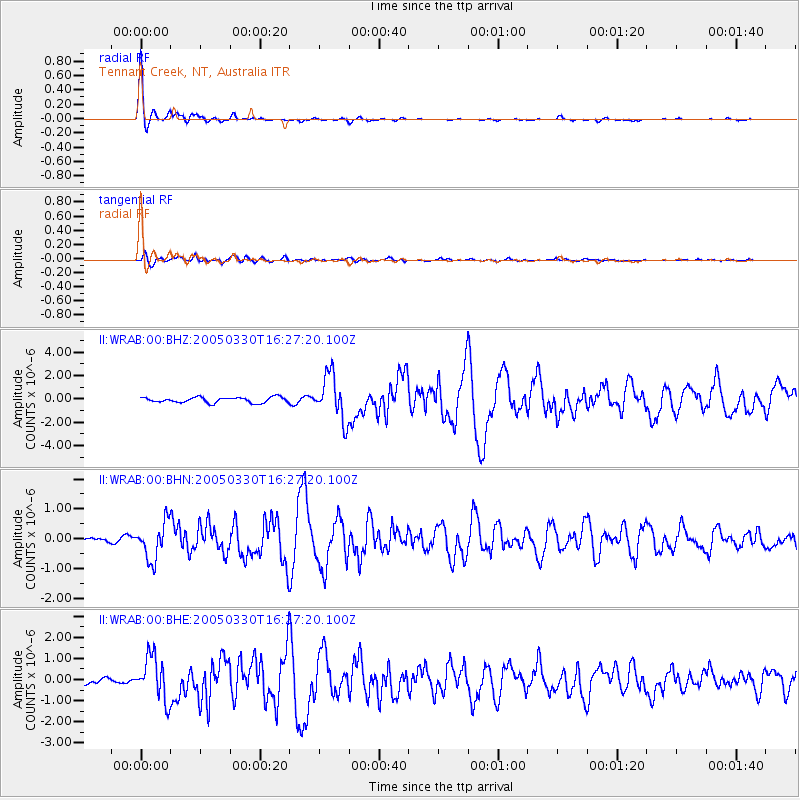
> Station WRAB Tennant Creek, NT, Australia > Earthquake Result Viewer
WRAB Tennant Creek, NT, Australia - Earthquake Result Viewer
| Earthquake location: |
Off W Coast Of Northern Sumatra |
| Earthquake latitude/longitude: |
3.0/95.4 |
| Earthquake time(UTC): |
2005/03/30 (089) 16:19:41 GMT |
| Earthquake Depth: |
22 km |
| Earthquake Magnitude: |
5.9 MB, 6.2 MS, 6.4 MW, 6.3 MW |
| Earthquake Catalog/Contributor: |
WHDF/NEIC |
|
| Network: |
II Global Seismograph Network (GSN - IRIS/IDA) |
| Station: |
WRAB Tennant Creek, NT, Australia |
| Lat/Lon: |
19.93 S/134.36 E |
| Elevation: |
366 m |
|
| Distance: |
44.5 deg |
| Az: |
122.476 deg |
| Baz: |
296.43 deg |
| Ray Param: |
0.07184185 |
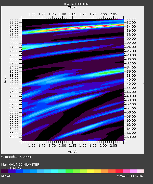
| Estimated Moho Depth: |
14.25 km |
| Estimated Crust Vp/Vs: |
1.91 |
| Assumed Crust Vp: |
6.642 km/s |
| Estimated Crust Vs: |
3.473 km/s |
| Estimated Crust Poisson's Ratio: |
0.31 |
|
| Radial Match: |
96.2993 % |
| Radial Bump: |
239 |
| Transverse Match: |
85.27769 % |
| Transverse Bump: |
400 |
| SOD ConfigId: |
2459 |
| Insert Time: |
2010-03-01 23:11:50.547 +0000 |
| GWidth: |
2.5 |
| Max Bumps: |
400 |
| Tol: |
0.001 |
|
Signal To Noise
| Channel | StoN | STA | LTA |
| II:WRAB:00:BHN:20050330T16:27:20.100Z | 5.1942477 | 6.263191E-7 | 1.2057937E-7 |
| II:WRAB:00:BHE:20050330T16:27:20.100Z | 8.77295 | 1.0439054E-6 | 1.1899137E-7 |
| II:WRAB:00:BHZ:20050330T16:27:20.100Z | 8.315833 | 1.921314E-6 | 2.3104288E-7 |
| Arrivals |
| Ps | 2.1 SECOND |
| PpPs | 5.9 SECOND |
| PsPs/PpSs | 7.9 SECOND |


