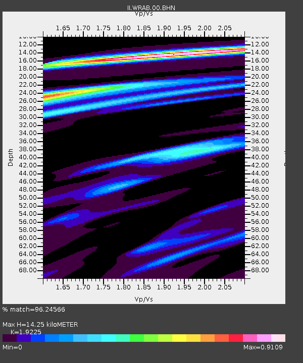
WRAB Tennant Creek, NT, Australia - Earthquake Result Viewer
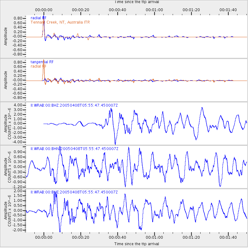
Earthquake location: Southwest Of Sumatra, Indonesia
Earthquake latitude/longitude: -0.2/97.7
Earthquake time(UTC): 2005/04/08 (098) 05:48:37 GMT
Earthquake Depth: 21 km
Earthquake Magnitude: 5.7 MB, 6.3 MS, 6.1 MW, 6.1 MW
Earthquake Catalog/Contributor: WHDF/NEIC
Network: II Global Seismograph Network (GSN - IRIS/IDA)
Station: WRAB Tennant Creek, NT, Australia
Lat/Lon: 19.93 S/134.36 E
Elevation: 366 m
Distance: 40.9 deg
Az: 120.911 deg
Baz: 294.227 deg
Ray Param: 0.074120276
Estimated Moho Depth: 14.25 km
Estimated Crust Vp/Vs: 1.92
Assumed Crust Vp: 6.642 km/s
Estimated Crust Vs: 3.455 km/s
Estimated Crust Poisson's Ratio: 0.31
Radial Match: 96.24566 %
Radial Bump: 297
Transverse Match: 67.34301 %
Transverse Bump: 400
SOD ConfigId: 2459
Insert Time: 2010-03-01 23:11:56.292 +0000
GWidth: 2.5
Max Bumps: 400
Tol: 0.001

Signal To Noise

ChannelStoNSTALTA
II:WRAB:00:BHN:20050408T05:55:47.450007Z1.27456622.9995766E-72.3534098E-7
II:WRAB:00:BHE:20050408T05:55:47.450007Z3.10901333.2972963E-71.0605604E-7
II:WRAB:00:BHZ:20050408T05:55:47.450007Z2.40417484.9914087E-72.0761422E-7
Arrivals
Ps2.1 SECOND
PpPs5.9 SECOND
PsPs/PpSs8.0 SECOND