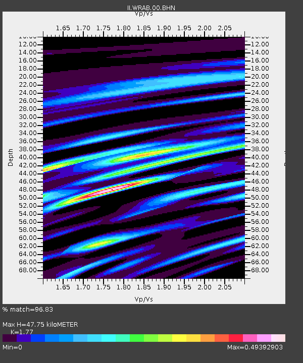
WRAB Tennant Creek, NT, Australia - Earthquake Result Viewer
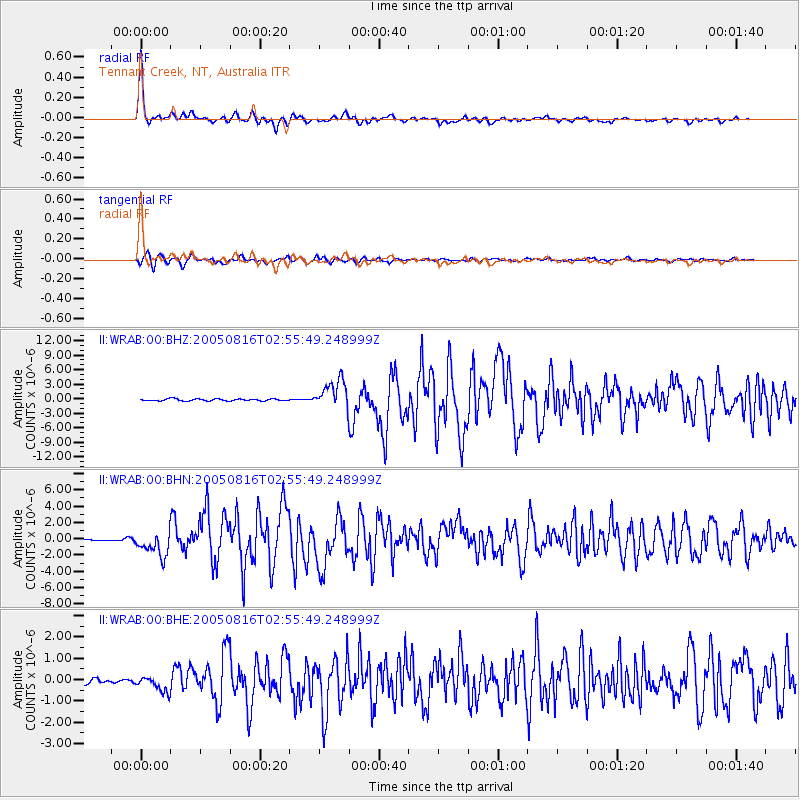
Earthquake location: Near East Coast Of Honshu, Japan
Earthquake latitude/longitude: 38.3/142.0
Earthquake time(UTC): 2005/08/16 (228) 02:46:28 GMT
Earthquake Depth: 36 km
Earthquake Magnitude: 6.5 MB, 6.8 MS, 7.2 MW, 7.1 MW
Earthquake Catalog/Contributor: WHDF/NEIC
Network: II Global Seismograph Network (GSN - IRIS/IDA)
Station: WRAB Tennant Creek, NT, Australia
Lat/Lon: 19.93 S/134.36 E
Elevation: 366 m
Distance: 58.3 deg
Az: 188.493 deg
Baz: 7.097 deg
Ray Param: 0.06283711
Estimated Moho Depth: 47.75 km
Estimated Crust Vp/Vs: 1.77
Assumed Crust Vp: 6.642 km/s
Estimated Crust Vs: 3.753 km/s
Estimated Crust Poisson's Ratio: 0.27
Radial Match: 96.83 %
Radial Bump: 313
Transverse Match: 87.23436 %
Transverse Bump: 400
SOD ConfigId: 2475
Insert Time: 2010-03-01 23:12:14.475 +0000
GWidth: 2.5
Max Bumps: 400
Tol: 0.001

Signal To Noise

ChannelStoNSTALTA
II:WRAB:00:BHN:20050816T02:55:49.248999Z8.2627631.5057213E-61.8222975E-7
II:WRAB:00:BHE:20050816T02:55:49.248999Z2.74995373.6530855E-71.3284172E-7
II:WRAB:00:BHZ:20050816T02:55:49.248999Z15.0103752.9202727E-61.9455028E-7
Arrivals
Ps5.8 SECOND
PpPs19 SECOND
PsPs/PpSs25 SECOND