You are here: Home > Network List > CI - Caltech Regional Seismic Network Stations List
> Station VCS Vincent SCE, California, USA > Earthquake Result Viewer
VCS Vincent SCE, California, USA - Earthquake Result Viewer
| Earthquake location: |
Caribbean Sea |
| Earthquake latitude/longitude: |
19.0/-81.4 |
| Earthquake time(UTC): |
2004/12/14 (349) 23:20:13 GMT |
| Earthquake Depth: |
10 km |
| Earthquake Magnitude: |
6.2 MB, 6.7 MS, 6.8 MW, 6.8 MW |
| Earthquake Catalog/Contributor: |
WHDF/NEIC |
|
| Network: |
CI Caltech Regional Seismic Network |
| Station: |
VCS Vincent SCE, California, USA |
| Lat/Lon: |
34.48 N/118.11 W |
| Elevation: |
962 m |
|
| Distance: |
36.0 deg |
| Az: |
302.911 deg |
| Baz: |
105.878 deg |
| Ray Param: |
0.076907806 |
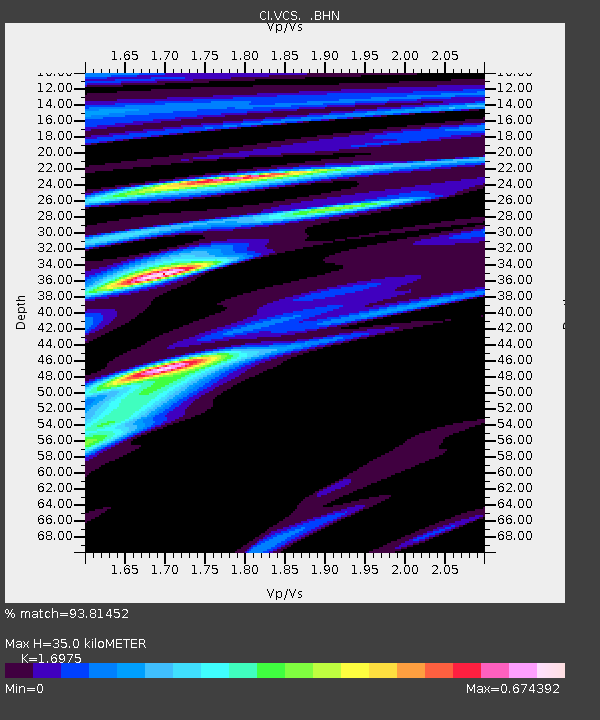
| Estimated Moho Depth: |
35.0 km |
| Estimated Crust Vp/Vs: |
1.70 |
| Assumed Crust Vp: |
6.1 km/s |
| Estimated Crust Vs: |
3.594 km/s |
| Estimated Crust Poisson's Ratio: |
0.23 |
|
| Radial Match: |
93.81452 % |
| Radial Bump: |
340 |
| Transverse Match: |
81.03221 % |
| Transverse Bump: |
400 |
| SOD ConfigId: |
2459 |
| Insert Time: |
2010-02-25 21:08:41.685 +0000 |
| GWidth: |
2.5 |
| Max Bumps: |
400 |
| Tol: |
0.001 |
|
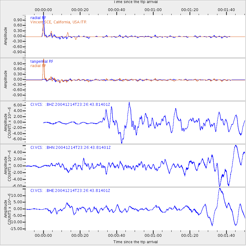
Signal To Noise
| Channel | StoN | STA | LTA |
| CI:VCS: :BHN:20041214T23:26:43.81401Z | 1.8385569 | 3.256618E-7 | 1.7712904E-7 |
| CI:VCS: :BHE:20041214T23:26:43.81401Z | 8.570202 | 1.1616744E-6 | 1.3554808E-7 |
| CI:VCS: :BHZ:20041214T23:26:43.81401Z | 7.465396 | 1.7932841E-6 | 2.4021284E-7 |
| Arrivals |
| Ps | 4.3 SECOND |
| PpPs | 14 SECOND |
| PsPs/PpSs | 19 SECOND |


