You are here: Home > Network List > TA - USArray Transportable Network (new EarthScope stations) Stations List
> Station I23K Minto, Yukon-Koyukuk, AK, USA > Earthquake Result Viewer
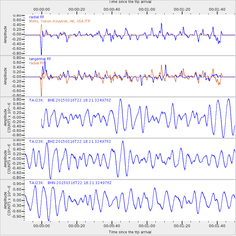
I23K Minto, Yukon-Koyukuk, AK, USA - Earthquake Result Viewer
*The percent match for this event was below the threshold and hence no stack was calculated.
| Earthquake location: |
New Britain Region, P.N.G. |
| Earthquake latitude/longitude: |
-5.6/151.1 |
| Earthquake time(UTC): |
2015/03/16 (075) 22:06:35 GMT |
| Earthquake Depth: |
65 km |
| Earthquake Magnitude: |
5.2 MW |
| Earthquake Catalog/Contributor: |
ISC/ISC |
|
| Network: |
TA USArray Transportable Network (new EarthScope stations) |
| Station: |
I23K Minto, Yukon-Koyukuk, AK, USA |
| Lat/Lon: |
65.15 N/149.36 W |
| Elevation: |
149 m |
|
| Distance: |
82.8 deg |
| Az: |
21.538 deg |
| Baz: |
239.832 deg |
| Ray Param: |
$rayparam |
*The percent match for this event was below the threshold and hence was not used in the summary stack. |
|
| Radial Match: |
59.932705 % |
| Radial Bump: |
400 |
| Transverse Match: |
49.435486 % |
| Transverse Bump: |
363 |
| SOD ConfigId: |
7422571 |
| Insert Time: |
2019-04-17 19:21:00.625 +0000 |
| GWidth: |
2.5 |
| Max Bumps: |
400 |
| Tol: |
0.001 |
|
Signal To Noise
| Channel | StoN | STA | LTA |
| TA:I23K: :BHZ:20150316T22:18:21.324976Z | 1.890052 | 4.147907E-7 | 2.1945993E-7 |
| TA:I23K: :BHN:20150316T22:18:21.324976Z | 2.2825644 | 6.638502E-7 | 2.9083526E-7 |
| TA:I23K: :BHE:20150316T22:18:21.324976Z | 0.6281677 | 1.3035506E-7 | 2.0751635E-7 |
| Arrivals |
| Ps | |
| PpPs | |
| PsPs/PpSs | |


