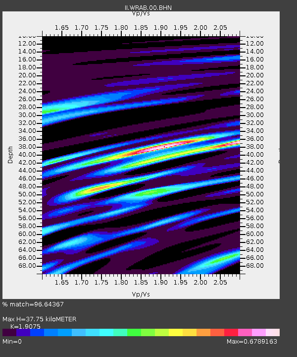
WRAB Tennant Creek, NT, Australia - Earthquake Result Viewer
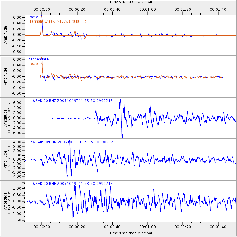
Earthquake location: Near East Coast Of Honshu, Japan
Earthquake latitude/longitude: 36.4/140.8
Earthquake time(UTC): 2005/10/19 (292) 11:44:42 GMT
Earthquake Depth: 32 km
Earthquake Magnitude: 6.2 MB, 6.5 MS, 6.4 MW, 6.3 MW
Earthquake Catalog/Contributor: WHDF/NEIC
Network: II Global Seismograph Network (GSN - IRIS/IDA)
Station: WRAB Tennant Creek, NT, Australia
Lat/Lon: 19.93 S/134.36 E
Elevation: 366 m
Distance: 56.4 deg
Az: 187.326 deg
Baz: 6.277 deg
Ray Param: 0.06413266
Estimated Moho Depth: 37.75 km
Estimated Crust Vp/Vs: 1.91
Assumed Crust Vp: 6.642 km/s
Estimated Crust Vs: 3.482 km/s
Estimated Crust Poisson's Ratio: 0.31
Radial Match: 96.64367 %
Radial Bump: 345
Transverse Match: 89.354774 %
Transverse Bump: 400
SOD ConfigId: 2475
Insert Time: 2010-03-01 23:12:22.279 +0000
GWidth: 2.5
Max Bumps: 400
Tol: 0.001

Signal To Noise

ChannelStoNSTALTA
II:WRAB:00:BHN:20051019T11:53:50.099021Z5.7702626.474475E-71.12204184E-7
II:WRAB:00:BHE:20051019T11:53:50.099021Z2.1630532.3051548E-71.0656951E-7
II:WRAB:00:BHZ:20051019T11:53:50.099021Z10.2774761.254117E-61.2202577E-7
Arrivals
Ps5.4 SECOND
PpPs16 SECOND
PsPs/PpSs21 SECOND